La Hulería geodata
La Hulería (Tabasco) is a populated place; located in Mexico in America/Mexico_City (GMT-6) time zone. With population of 938 people, there are 9294 cities with bigger population in this country. Compared to other cities in Mexico, 78.7% of cities are located further ↑North; 96.5% of cities are located further ←West and 84.1% of cities have higher elevation than La Hulería. Note1


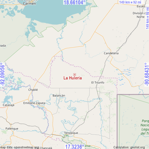
La Hulería GPS coordinates[2]
17° 59' 36.924" North, 91° 23' 14.748" West
| Map corner | latitude | longitude |
|---|---|---|
| Upper-left | 18.66104°, | -92.09056° |
| Center: | 17.99359°, | -91.38743° |
| Lower-right: | 17.3236°, | -90.68431° |
| Map W x H: | 148.7×148.7 km | = 92.4×92.4mi |
| max Lat: | 32.7° ⇑78.7% North |
| La Hulería: | 17.99359° |
| min Lat: | ⇓21.3% South 14.53588° |
| min Long | La Hulería | max Long |
| -117.105° | -91.38743° | -86.73105° |
| W 96.5%⇐ | ⇒3.5% E |
Elevation
Elevation of La Hulería is 51 m = 167 ft, and this is 1202.7 m = 3946 ft below average elevation for this country.
| Max E: |
3497 m = 11473 ft | 84.1% |
| Avg. | 1253.7 m = 4113 ft | |
| La Hulería | 51 m = 167 ft | |
Min E: |
-1 m = -3 ft | 15.9% |
See also: Mexico elevation on elevation.city.
Geographical zone
La Hulería is located in North Torrid zone (between Equator and Tropic of Cancer). Distance of this Northern Tropic circle is 605.2 km =376.1 mi to North.| Distance of | km | miles | from La Hulería |
|---|---|---|---|
| North Pole | 8006.4 | 4974.9 | to North |
| Arctic Circle | 5400.5 | 3355.7 | to North |
| Tropic Cancer | 605.2 | 376.1 | to North |
| Equator | 2000.7 | 1243.2 | to South |


Nearby cities:
15 places around La Hulería: (largest is in red/bold)
• Balancán
25.9 km =16.1 mi,  217°
217°
• Capitán Felipe Castellanos Díaz (San Pedro)
35.3 km =21.9 mi,  134°
134°
• Conquista Campesina
23.2 km =14.4 mi,  26°
26°
• Constitución
26.9 km =16.7 mi,  311°
311°
• El Aguacatal
27.7 km =17.2 mi,  331°
331°
• El Naranjito
30.9 km =19.2 mi,  124°
124°
• El Naranjo
27.8 km =17.3 mi,  83°
83°
• El Pípila
22.6 km =14 mi,  261°
261°
• El Triunfo
24.4 km =15.2 mi,  108°
108°
• Leona Vicario
37.3 km =23.2 mi,  206°
206°
• Missicab (La Pita)
17.9 km =11.1 mi,  177°
177°
• Multé
33.9 km =21.1 mi, 178°
• Netzahualcóyotl
32 km =19.9 mi,  190°
190°
• Ojo de Agua
30.3 km =18.8 mi, 115°
• Vicente Guerrero
36.4 km =22.6 mi,  226°
226°
Sources, notices
• [Note1] Compared only with cities in Mexico existing in our database
• [Src1] Map data: © OpenStreetMap contributors (CC-BY-SA)
• [Src2] Other city data from geonames.org with taken over terms of usage.
• [Src3] Geographical zone / Annual Mean Temperature by Robert A. Rohde @ Wikipedia
