El Pípila geodata
El Pípila (Tabasco) is a populated place; located in Mexico in America/Mexico_City (GMT-6) time zone. With population of 512 people, there are 16417 cities with bigger population in this country. Compared to other cities in Mexico, 79.1% of cities are located further ↑North; 96.2% of cities are located further ←West and 93% of cities have higher elevation than El Pípila. Note1


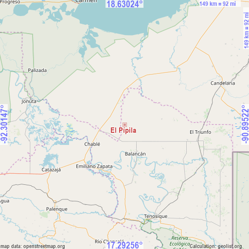
El Pípila GPS coordinates[2]
17° 57' 45.612" North, 91° 35' 54.024" West
| Map corner | latitude | longitude |
|---|---|---|
| Upper-left | 18.63024°, | -92.30147° |
| Center: | 17.96267°, | -91.59834° |
| Lower-right: | 17.29256°, | -90.89522° |
| Map W x H: | 148.7×148.7 km | = 92.4×92.4mi |
| max Lat: | 32.7° ⇑79.1% North |
| El Pípila: | 17.96267° |
| min Lat: | ⇓20.9% South 14.53588° |
| min Long | El Pípila | max Long |
| -117.105° | -91.59834° | -86.73105° |
| W 96.2%⇐ | ⇒3.8% E |
Elevation
Elevation of El Pípila is 17 m = 56 ft, and this is 1236.7 m = 4057 ft below average elevation for this country.
| Max E: |
3497 m = 11473 ft | 93% |
| Avg. | 1253.7 m = 4113 ft | |
| El Pípila | 17 m = 56 ft | |
Min E: |
-1 m = -3 ft | 7% |
See also: Mexico elevation on elevation.city.
Geographical zone
El Pípila is located in North Torrid zone (between Equator and Tropic of Cancer). Distance of this Northern Tropic circle is 608.7 km =378.2 mi to North.| Distance of | km | miles | from El Pípila |
|---|---|---|---|
| North Pole | 8009.8 | 4977.1 | to North |
| Arctic Circle | 5403.9 | 3357.8 | to North |
| Tropic Cancer | 608.7 | 378.2 | to North |
| Equator | 1997.3 | 1241.1 | to South |


Nearby cities:
15 places around El Pípila: (largest is in red/bold)
• Balancán
18.3 km =11.4 mi,  159°
159°
• Calatraba
28.5 km =17.7 mi,  224°
224°
• Chablé
22.5 km =14 mi,  239°
239°
• Chacama
33.7 km =20.9 mi,  183°
183°
• Constitución
21.3 km =13.2 mi,  5°
5°
• El Aguacatal
29.4 km =18.3 mi,  18°
18°
• Emiliano Zapata
30.4 km =18.9 mi, 215°
• La Guayaba (Alto Amatitán)
24.3 km =15.1 mi,  253°
253°
• La Hulería
22.6 km =14 mi,  81°
81°
• La Libertad
33.2 km =20.6 mi,  202°
202°
• Leona Vicario
30.7 km =19.1 mi,  168°
168°
• Missicab (La Pita)
27.3 km =17 mi,  121°
121°
• Netzahualcóyotl
32.5 km =20.2 mi,  149°
149°
• Playa Larga
22.3 km =13.9 mi,  261°
261°
• Vicente Guerrero
22.1 km =13.7 mi,  190°
190°
Sources, notices
• [Note1] Compared only with cities in Mexico existing in our database
• [Src1] Map data: © OpenStreetMap contributors (CC-BY-SA)
• [Src2] Other city data from geonames.org with taken over terms of usage.
• [Src3] Geographical zone / Annual Mean Temperature by Robert A. Rohde @ Wikipedia
