Multé geodata
Multé (Tabasco) is a populated place; located in Mexico in America/Mexico_City (GMT-6) time zone. With population of 1,562 people, there are 5526 cities with bigger population in this country. Compared to other cities in Mexico, 81.4% of cities are located further ↑North; 96.5% of cities are located further ←West and 92.1% of cities have higher elevation than Multé. Note1


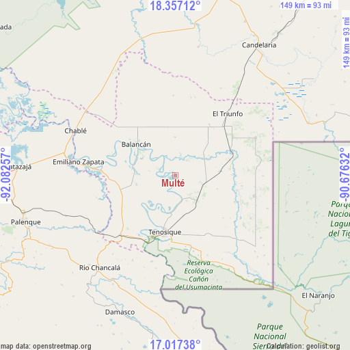
Multé GPS coordinates[2]
17° 41' 18.6" North, 91° 22' 45.984" West
| Map corner | latitude | longitude |
|---|---|---|
| Upper-left | 18.35712°, | -92.08257° |
| Center: | 17.6885°, | -91.37944° |
| Lower-right: | 17.01738°, | -90.67632° |
| Map W x H: | 149×149 km | = 92.6×92.6mi |
| max Lat: | 32.7° ⇑81.4% North |
| Multé: | 17.6885° |
| min Lat: | ⇓18.6% South 14.53588° |
| min Long | Multé | max Long |
| -117.105° | -91.37944° | -86.73105° |
| W 96.5%⇐ | ⇒3.5% E |
Elevation
Elevation of Multé is 19 m = 62 ft, and this is 1234.7 m = 4051 ft below average elevation for this country.
| Max E: |
3497 m = 11473 ft | 92.1% |
| Avg. | 1253.7 m = 4113 ft | |
| Multé | 19 m = 62 ft | |
Min E: |
-1 m = -3 ft | 7.9% |
See also: Mexico elevation on elevation.city.
Geographical zone
Multé is located in North Torrid zone (between Equator and Tropic of Cancer). Distance of this Northern Tropic circle is 639.1 km =397.1 mi to North.| Distance of | km | miles | from Multé |
|---|---|---|---|
| North Pole | 8040.3 | 4996 | to North |
| Arctic Circle | 5434.4 | 3376.8 | to North |
| Tropic Cancer | 639.1 | 397.1 | to North |
| Equator | 1966.8 | 1222.1 | to South |


Nearby cities:
15 places around Multé: (largest is in red/bold)
• Balancán
21.4 km =13.3 mi,  308°
308°
• Capitán Felipe Castellanos Díaz (San Pedro)
26.3 km =16.3 mi,  69°
69°
• Certeza
25.4 km =15.8 mi,  177°
177°
• Chacama
25.2 km =15.7 mi,  262°
262°
• El Águila
12.7 km =7.9 mi,  107°
107°
• Estapilla
16.2 km =10.1 mi,  189°
189°
• General Luis Felipe Domínguez Suárez
17 km =10.6 mi, 257°
• La Isla
25.7 km =16 mi,  205°
205°
• Leona Vicario
17.2 km =10.7 mi,  271°
271°
• Mactún
14.3 km =8.9 mi,  140°
140°
• Missicab (La Pita)
16 km =9.9 mi,  0°
0°
• Netzahualcóyotl
7.2 km =4.5 mi,  290°
290°
• Paraíso (El Tinto)
27.5 km =17.1 mi, 114°
• Tenosique
24.4 km =15.2 mi, 191°
• Usumacinta
19.3 km =12 mi,  218°
218°
Sources, notices
• [Note1] Compared only with cities in Mexico existing in our database
• [Src1] Map data: © OpenStreetMap contributors (CC-BY-SA)
• [Src2] Other city data from geonames.org with taken over terms of usage.
• [Src3] Geographical zone / Annual Mean Temperature by Robert A. Rohde @ Wikipedia
