Netzahualcóyotl geodata
Netzahualcóyotl (Tabasco) is a populated place; located in Mexico in America/Mexico_City (GMT-6) time zone. With population of 1,210 people, there are 7193 cities with bigger population in this country. Compared to other cities in Mexico, 81.2% of cities are located further ↑North; 96.4% of cities are located further ←West and 93.5% of cities have higher elevation than Netzahualcóyotl. Note1


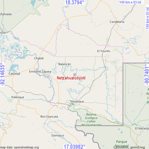
Netzahualcóyotl GPS coordinates[2]
17° 42' 39.096" North, 91° 26' 35.592" West
| Map corner | latitude | longitude |
|---|---|---|
| Upper-left | 18.3794°, | -92.14635° |
| Center: | 17.71086°, | -91.44322° |
| Lower-right: | 17.03982°, | -90.7401° |
| Map W x H: | 148.9×148.9 km | = 92.5×92.5mi |
| max Lat: | 32.7° ⇑81.2% North |
| Netzahualcóyotl: | 17.71086° |
| min Lat: | ⇓18.8% South 14.53588° |
| min Long | Netzahualcóyot | max Long |
| -117.105° | -91.44322° | -86.73105° |
| W 96.4%⇐ | ⇒3.6% E |
Elevation
Elevation of Netzahualcóyotl is 16 m = 52 ft, and this is 1237.7 m = 4061 ft below average elevation for this country.
| Max E: |
3497 m = 11473 ft | 93.5% |
| Avg. | 1253.7 m = 4113 ft | |
| Netzahualcóyotl | 16 m = 52 ft | |
Min E: |
-1 m = -3 ft | 6.5% |
See also: Mexico elevation on elevation.city.
Geographical zone
Netzahualcóyotl is located in North Torrid zone (between Equator and Tropic of Cancer). Distance of this Northern Tropic circle is 636.7 km =395.6 mi to North.| Distance of | km | miles | from Netzahualcóyotl |
|---|---|---|---|
| North Pole | 8037.8 | 4994.5 | to North |
| Arctic Circle | 5431.9 | 3375.2 | to North |
| Tropic Cancer | 636.7 | 395.6 | to North |
| Equator | 1969.3 | 1223.7 | to South |


Nearby cities:
15 places around Netzahualcóyotl: (largest is in red/bold)
• Balancán
14.7 km =9.1 mi,  317°
317°
• Benito Juárez Centro
29.5 km =18.3 mi,  245°
245°
• Certeza
28.9 km =18 mi,  164°
164°
• Chacama
19.1 km =11.9 mi, 252°
• El Águila
19.9 km =12.4 mi,  108°
108°
• Estapilla
18.9 km =11.7 mi,  167°
167°
• General Luis Felipe Domínguez Suárez
11.6 km =7.2 mi,  238°
238°
• La Isla
26 km =16.2 mi,  189°
189°
• Leona Vicario
10.7 km =6.6 mi,  258°
258°
• Mactún
20.8 km =12.9 mi,  130°
130°
• Missicab (La Pita)
15.2 km =9.4 mi,  26°
26°
• Multé
7.2 km =4.5 mi, 110°
• Tenosique
26.5 km =16.5 mi,  175°
175°
• Usumacinta
18.3 km =11.4 mi,  196°
196°
• Vicente Guerrero
21.3 km =13.2 mi,  287°
287°
Sources, notices
• [Note1] Compared only with cities in Mexico existing in our database
• [Src1] Map data: © OpenStreetMap contributors (CC-BY-SA)
• [Src2] Other city data from geonames.org with taken over terms of usage.
• [Src3] Geographical zone / Annual Mean Temperature by Robert A. Rohde @ Wikipedia
