Lagunillas geodata
Lagunillas (San Luis Potosí) is a seat of a second-order administrative division; located in Mexico in America/Mexico_City (GMT-6) time zone. With population of 475 people, there are 16824 cities with bigger population in this country. Compared to other cities in Mexico, 81.9% of cities are located further ↓South; 57.9% of cities are located further →East and 61.1% of cities have higher elevation than Lagunillas. Note1


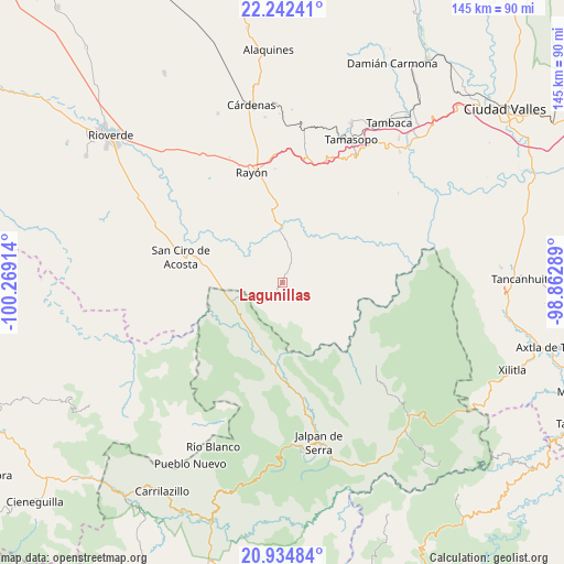
Lagunillas GPS coordinates[2]
21° 35' 24.36" North, 99° 33' 57.636" West
| Map corner | latitude | longitude |
|---|---|---|
| Upper-left | 22.24241°, | -100.26914° |
| Center: | 21.5901°, | -99.56601° |
| Lower-right: | 20.93484°, | -98.86289° |
| Map W x H: | 145.4×145.4 km | = 90.3×90.3mi |
| max Lat: | 32.7° ⇑18.1% North |
| Lagunillas: | 21.5901° |
| min Lat: | ⇓81.9% South 14.53588° |
| min Long | Lagunillas | max Long |
| -117.105° | -99.56601° | -86.73105° |
| W 42.1%⇐ | ⇒57.9% E |
Elevation
Elevation of Lagunillas is 933 m = 3061 ft, and this is 320.7 m = 1052 ft below average elevation for this country.
| Max E: |
3497 m = 11473 ft | 61.1% |
| Avg. | 1253.7 m = 4113 ft | |
| Lagunillas | 933 m = 3061 ft | |
Min E: |
-1 m = -3 ft | 38.9% |
See also: Mexico elevation on elevation.city.
Geographical zone
Lagunillas is located in North Torrid zone (between Equator and Tropic of Cancer). Distance of this Northern Tropic circle is 205.3 km =127.6 mi to North.| Distance of | km | miles | from Lagunillas |
|---|---|---|---|
| North Pole | 7606.5 | 4726.5 | to North |
| Arctic Circle | 5000.6 | 3107.2 | to North |
| Tropic Cancer | 205.3 | 127.6 | to North |
| Equator | 2400.6 | 1491.7 | to South |


Nearby cities:
15 places around Lagunillas: (largest is in red/bold)
• Arroyo Seco
13.5 km =8.4 mi,  249°
249°
• Concá
17.7 km =11 mi,  204°
204°
• Cuesta Blanca
28.7 km =17.8 mi,  26°
26°
• El Pajarito
19 km =11.8 mi,  323°
323°
• El Puente (Ejido Guayabos)
15.4 km =9.6 mi,  37°
37°
• La Parada
13.4 km =8.3 mi,  127°
127°
• Pinihuan
13.5 km =8.4 mi,  358°
358°
• Purísima de Arista
31.5 km =19.6 mi,  169°
169°
• Rayón
29.2 km =18.1 mi,  344°
344°
• San Ciro de Acosta
27 km =16.8 mi,  284°
284°
• San Diego (Pueblo Viejo)
13.2 km =8.2 mi,  141°
141°
• San Rafael
14.7 km =9.1 mi,  269°
269°
• Santa Catarina
10.4 km =6.5 mi, 44°
• Santa María Acapulco
18.4 km =11.4 mi, 135°
• Tanlacut (Labor Zapata)
26.3 km =16.3 mi,  69°
69°
Sources, notices
• [Note1] Compared only with cities in Mexico existing in our database
• [Src1] Map data: © OpenStreetMap contributors (CC-BY-SA)
• [Src2] Other city data from geonames.org with taken over terms of usage.
• [Src3] Geographical zone / Annual Mean Temperature by Robert A. Rohde @ Wikipedia
