Jonuta geodata
Jonuta (Tabasco) is a seat of a second-order administrative division; located in Mexico in America/Mexico_City (GMT-6) time zone. With population of 6,899 people, there are 1352 cities with bigger population in this country. Compared to other cities in Mexico, 77.7% of cities are located further ↑North; 94.6% of cities are located further ←West and 98.1% of cities have higher elevation than Jonuta. Note1


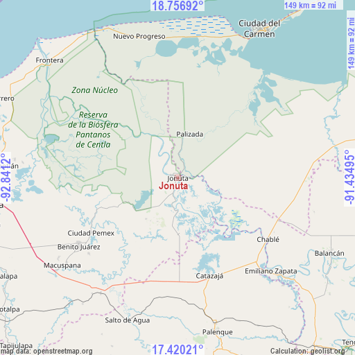
Jonuta GPS coordinates[2]
18° 5' 23.424" North, 92° 8' 17.052" West
| Map corner | latitude | longitude |
|---|---|---|
| Upper-left | 18.75692°, | -92.8412° |
| Center: | 18.08984°, | -92.13807° |
| Lower-right: | 17.42021°, | -91.43495° |
| Map W x H: | 148.6×148.6 km | = 92.3×92.3mi |
| max Lat: | 32.7° ⇑77.7% North |
| Jonuta: | 18.08984° |
| min Lat: | ⇓22.3% South 14.53588° |
| min Long | Jonuta | max Long |
| -117.105° | -92.13807° | -86.73105° |
| W 94.6%⇐ | ⇒5.4% E |
Elevation
Elevation of Jonuta is 8 m = 26 ft, and this is 1245.7 m = 4087 ft below average elevation for this country.
| Max E: |
3497 m = 11473 ft | 98.1% |
| Avg. | 1253.7 m = 4113 ft | |
| Jonuta | 8 m = 26 ft | |
Min E: |
-1 m = -3 ft | 1.9% |
See also: Mexico elevation on elevation.city.
Geographical zone
Jonuta is located in North Torrid zone (between Equator and Tropic of Cancer). Distance of this Northern Tropic circle is 594.5 km =369.4 mi to North.| Distance of | km | miles | from Jonuta |
|---|---|---|---|
| North Pole | 7995.7 | 4968.3 | to North |
| Arctic Circle | 5389.8 | 3349.1 | to North |
| Tropic Cancer | 594.5 | 369.4 | to North |
| Equator | 2011.4 | 1249.8 | to South |


Nearby cities:
15 places around Jonuta: (largest is in red/bold)
• Boca de San Jerónimo
31.5 km =19.6 mi,  130°
130°
• El Paraíso
34.6 km =21.5 mi,  163°
163°
• El Rosario
31.8 km =19.8 mi,  172°
172°
• Ignacio Zaragoza
37.1 km =23.1 mi, 155°
• José María Pino Suárez
25.6 km =15.9 mi,  339°
339°
• Loma Bonita
34.3 km =21.3 mi, 169°
• Los Pájaros
21.1 km =13.1 mi, 162°
• Monte Grande
21.8 km =13.5 mi,  217°
217°
• Palizada
19 km =11.8 mi,  15°
15°
• Ramón Grande
33 km =20.5 mi,  202°
202°
• Sacrificio
0.8 km =0.5 mi,  179°
179°
• San José
25 km =15.5 mi,  313°
313°
• Santa Isabel
27.8 km =17.3 mi,  9°
9°
• Torno Largo 2da. Sección
22.6 km =14 mi,  147°
147°
• Venustiano Carranza
36.6 km =22.7 mi, 197°
Sources, notices
• [Note1] Compared only with cities in Mexico existing in our database
• [Src1] Map data: © OpenStreetMap contributors (CC-BY-SA)
• [Src2] Other city data from geonames.org with taken over terms of usage.
• [Src3] Geographical zone / Annual Mean Temperature by Robert A. Rohde @ Wikipedia
