Los Pájaros geodata
Los Pájaros (Tabasco) is a populated place; located in Mexico in America/Mexico_City (GMT-6) time zone. With population of 517 people, there are 16282 cities with bigger population in this country. Compared to other cities in Mexico, 79.6% of cities are located further ↑North; 94.9% of cities are located further ←West and 98.7% of cities have higher elevation than Los Pájaros. Note1


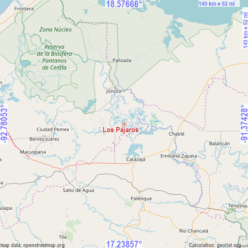
Los Pájaros GPS coordinates[2]
17° 54' 31.968" North, 92° 4' 38.64" West
| Map corner | latitude | longitude |
|---|---|---|
| Upper-left | 18.57666°, | -92.78053° |
| Center: | 17.90888°, | -92.0774° |
| Lower-right: | 17.23857°, | -91.37428° |
| Map W x H: | 148.8×148.8 km | = 92.5×92.5mi |
| max Lat: | 32.7° ⇑79.6% North |
| Los Pájaros: | 17.90888° |
| min Lat: | ⇓20.4% South 14.53588° |
| min Long | Los Pájaros | max Long |
| -117.105° | -92.0774° | -86.73105° |
| W 94.9%⇐ | ⇒5.1% E |
Elevation
Elevation of Los Pájaros is 7 m = 23 ft, and this is 1246.7 m = 4090 ft below average elevation for this country.
| Max E: |
3497 m = 11473 ft | 98.7% |
| Avg. | 1253.7 m = 4113 ft | |
| Los Pájaros | 7 m = 23 ft | |
Min E: |
-1 m = -3 ft | 1.3% |
See also: Mexico elevation on elevation.city.
Geographical zone
Los Pájaros is located in North Torrid zone (between Equator and Tropic of Cancer). Distance of this Northern Tropic circle is 614.6 km =381.9 mi to North.| Distance of | km | miles | from Los Pájaros |
|---|---|---|---|
| North Pole | 8015.8 | 4980.8 | to North |
| Arctic Circle | 5409.9 | 3361.6 | to North |
| Tropic Cancer | 614.6 | 381.9 | to North |
| Equator | 1991.3 | 1237.3 | to South |


Nearby cities:
15 places around Los Pájaros: (largest is in red/bold)
• Agua Fría
18.3 km =11.4 mi,  186°
186°
• Boca de San Jerónimo
17.4 km =10.8 mi,  91°
91°
• Catazajá
21.7 km =13.5 mi,  161°
161°
• Cuauhtémoc
23.4 km =14.5 mi,  184°
184°
• El Paraíso
13.5 km =8.4 mi, 164°
• El Rosario
11.7 km =7.3 mi, 191°
• Ignacio Zaragoza
16.3 km =10.1 mi,  146°
146°
• Jonuta
21.1 km =13.1 mi,  342°
342°
• Loma Bonita
13.6 km =8.5 mi, 179°
• Monte Grande
20 km =12.4 mi,  278°
278°
• Punta Arena
18.2 km =11.3 mi,  173°
173°
• Ramón Grande
21.7 km =13.5 mi,  241°
241°
• Sacrificio
20.3 km =12.6 mi, 341°
• Torno Largo 2da. Sección
5.8 km =3.6 mi,  79°
79°
• Venustiano Carranza
22.9 km =14.2 mi,  229°
229°
Sources, notices
• [Note1] Compared only with cities in Mexico existing in our database
• [Src1] Map data: © OpenStreetMap contributors (CC-BY-SA)
• [Src2] Other city data from geonames.org with taken over terms of usage.
• [Src3] Geographical zone / Annual Mean Temperature by Robert A. Rohde @ Wikipedia
