Ramón Grande geodata
Ramón Grande (Tabasco) is a populated place; located in Mexico in America/Mexico_City (GMT-6) time zone. With population of 936 people, there are 9311 cities with bigger population in this country. Compared to other cities in Mexico, 80.4% of cities are located further ↑North; 93.7% of cities are located further ←West and 98.1% of cities have higher elevation than Ramón Grande. Note1


Ramón Grande GPS coordinates[2]
17° 48' 59.148" North, 92° 15' 29.7" West
| Map corner | latitude | longitude |
|---|---|---|
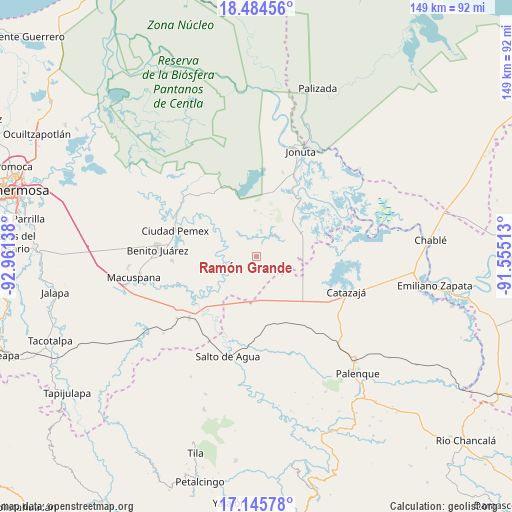
| Upper-left | 18.48456°, | -92.96138° |
| Center: | 17.81643°, | -92.25825° |
| Lower-right: | 17.14578°, | -91.55513° |
| Map W x H: | 148.9×148.9 km | = 92.5×92.5mi |
| max Lat: | 32.7° ⇑80.4% North |
| Ramón Grande: | 17.81643° |
| min Lat: | ⇓19.6% South 14.53588° |
| min Long | Ramón Grande | max Long |
| -117.105° | -92.25825° | -86.73105° |
| W 93.7%⇐ | ⇒6.3% E |
Elevation
Elevation of Ramón Grande is 8 m = 26 ft, and this is 1245.7 m = 4087 ft below average elevation for this country.
| Max E: |
3497 m = 11473 ft | 98.1% |
| Avg. | 1253.7 m = 4113 ft | |
| Ramón Grande | 8 m = 26 ft | |
Min E: |
-1 m = -3 ft | 1.9% |
See also: Mexico elevation on elevation.city.
Geographical zone
Ramón Grande is located in North Torrid zone (between Equator and Tropic of Cancer). Distance of this Northern Tropic circle is 624.9 km =388.3 mi to North.| Distance of | km | miles | from Ramón Grande |
|---|---|---|---|
| North Pole | 8026.1 | 4987.2 | to North |
| Arctic Circle | 5420.2 | 3368 | to North |
| Tropic Cancer | 624.9 | 388.3 | to North |
| Equator | 1981 | 1230.9 | to South |


Nearby cities:
15 places around Ramón Grande: (largest is in red/bold)
• Agua Fría
18.8 km =11.7 mi,  114°
114°
• Alcalde Mayor
12.4 km =7.7 mi,  206°
206°
• Aquiles Serdán
4.5 km =2.8 mi,  215°
215°
• Bajadas Grandes
12.9 km =8 mi,  181°
181°
• Cuauhtémoc
21.5 km =13.4 mi,  127°
127°
• El Congo
19.1 km =11.9 mi,  272°
272°
• El Rosario
16.8 km =10.4 mi,  94°
94°
• Emilio Rabasa
16.3 km =10.1 mi,  144°
144°
• La Ceiba
21.1 km =13.1 mi,  259°
259°
• Loma Bonita
19.5 km =12.1 mi,  99°
99°
• Los Pájaros
21.7 km =13.5 mi,  61°
61°
• Monte Grande
13.2 km =8.2 mi,  357°
357°
• Saturnino Ríos
22.3 km =13.9 mi,  161°
161°
• Tepetitán
12.1 km =7.5 mi, 271°
• Venustiano Carranza
4.7 km =2.9 mi, 160°
Sources, notices
• [Note1] Compared only with cities in Mexico existing in our database
• [Src1] Map data: © OpenStreetMap contributors (CC-BY-SA)
• [Src2] Other city data from geonames.org with taken over terms of usage.
• [Src3] Geographical zone / Annual Mean Temperature by Robert A. Rohde @ Wikipedia
