Venustiano Carranza geodata
Venustiano Carranza (Tabasco) is a populated place; located in Mexico in America/Mexico_City (GMT-6) time zone. With population of 601 people, there are 14318 cities with bigger population in this country. Compared to other cities in Mexico, 80.7% of cities are located further ↑North; 93.8% of cities are located further ←West and 97.5% of cities have higher elevation than Venustiano Carranza. Note1


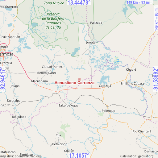
Venustiano Carranza GPS coordinates[2]
17° 46' 35.364" North, 92° 14' 34.944" West
| Map corner | latitude | longitude |
|---|---|---|
| Upper-left | 18.44478°, | -92.94617° |
| Center: | 17.77649°, | -92.24304° |
| Lower-right: | 17.1057°, | -91.53992° |
| Map W x H: | 148.9×148.9 km | = 92.5×92.5mi |
| max Lat: | 32.7° ⇑80.7% North |
| Venustiano Carranza: | 17.77649° |
| min Lat: | ⇓19.3% South 14.53588° |
| min Long | Venustiano Carr | max Long |
| -117.105° | -92.24304° | -86.73105° |
| W 93.8%⇐ | ⇒6.2% E |
Elevation
Elevation of Venustiano Carranza is 9 m = 30 ft, and this is 1244.7 m = 4084 ft below average elevation for this country.
| Max E: |
3497 m = 11473 ft | 97.5% |
| Avg. | 1253.7 m = 4113 ft | |
| Venustiano Carranza | 9 m = 30 ft | |
Min E: |
-1 m = -3 ft | 2.5% |
See also: Mexico elevation on elevation.city.
Geographical zone
Venustiano Carranza is located in North Torrid zone (between Equator and Tropic of Cancer). Distance of this Northern Tropic circle is 629.4 km =391.1 mi to North.| Distance of | km | miles | from Venustiano Carranza |
|---|---|---|---|
| North Pole | 8030.5 | 4989.9 | to North |
| Arctic Circle | 5424.6 | 3370.7 | to North |
| Tropic Cancer | 629.4 | 391.1 | to North |
| Equator | 1976.6 | 1228.2 | to South |


Nearby cities:
15 places around Venustiano Carranza: (largest is in red/bold)
• Agua Fría
15.9 km =9.9 mi,  102°
102°
• Alcalde Mayor
9.8 km =6.1 mi,  227°
227°
• Aquiles Serdán
4.3 km =2.7 mi,  280°
280°
• Bajadas Grandes
8.6 km =5.3 mi,  193°
193°
• Cuauhtémoc
17.7 km =11 mi,  119°
119°
• El Congo
21.4 km =13.3 mi, 284°
• El Paraíso
21.3 km =13.2 mi,  85°
85°
• El Rosario
15.5 km =9.6 mi,  77°
77°
• Emilio Rabasa
11.8 km =7.3 mi,  138°
138°
• Loma Bonita
17.7 km =11 mi, 86°
• Monte Grande
17.8 km =11.1 mi,  352°
352°
• Punta Arena
19.8 km =12.3 mi, 99°
• Ramón Grande
4.7 km =2.9 mi,  340°
340°
• Saturnino Ríos
17.6 km =10.9 mi,  162°
162°
• Tepetitán
14.5 km =9 mi,  289°
289°
Sources, notices
• [Note1] Compared only with cities in Mexico existing in our database
• [Src1] Map data: © OpenStreetMap contributors (CC-BY-SA)
• [Src2] Other city data from geonames.org with taken over terms of usage.
• [Src3] Geographical zone / Annual Mean Temperature by Robert A. Rohde @ Wikipedia
