Jamapa geodata
Jamapa (Veracruz) is a seat of a second-order administrative division; located in Mexico in America/Mexico_City (GMT-6) time zone. With population of 3,928 people, there are 2326 cities with bigger population in this country. Compared to other cities in Mexico, 64% of cities are located further ↑North; 81.1% of cities are located further ←West and 90.4% of cities have higher elevation than Jamapa. Note1


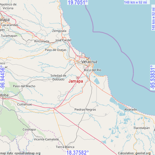
Jamapa GPS coordinates[2]
19° 2' 30.444" North, 96° 14' 29.148" West
| Map corner | latitude | longitude |
|---|---|---|
| Upper-left | 19.7051°, | -96.94456° |
| Center: | 19.04179°, | -96.24143° |
| Lower-right: | 18.37582°, | -95.53831° |
| Map W x H: | 147.8×147.8 km | = 91.8×91.8mi |
| max Lat: | 32.7° ⇑64% North |
| Jamapa: | 19.04179° |
| min Lat: | ⇓36% South 14.53588° |
| min Long | Jamapa | max Long |
| -117.105° | -96.24143° | -86.73105° |
| W 81.1%⇐ | ⇒18.9% E |
Elevation
Elevation of Jamapa is 23 m = 75 ft, and this is 1230.7 m = 4038 ft below average elevation for this country.
| Max E: |
3497 m = 11473 ft | 90.4% |
| Avg. | 1253.7 m = 4113 ft | |
| Jamapa | 23 m = 75 ft | |
Min E: |
-1 m = -3 ft | 9.6% |
See also: Mexico elevation on elevation.city.
Geographical zone
Jamapa is located in North Torrid zone (between Equator and Tropic of Cancer). Distance of this Northern Tropic circle is 488.7 km =303.7 mi to North.| Distance of | km | miles | from Jamapa |
|---|---|---|---|
| North Pole | 7889.8 | 4902.5 | to North |
| Arctic Circle | 5283.9 | 3283.3 | to North |
| Tropic Cancer | 488.7 | 303.7 | to North |
| Equator | 2117.2 | 1315.6 | to South |


Nearby cities:
15 places around Jamapa: (largest is in red/bold)
• Colina de los Pájaros
10.9 km =6.8 mi,  6°
6°
• Colonia Cardenista Antonio Luna
10.6 km =6.6 mi, 8°
• Colonia Lázaro Cárdenas
8.1 km =5 mi,  80°
80°
• El Tejar
9.2 km =5.7 mi,  66°
66°
• Fraccionamiento Arboledas San Ramón
10.6 km =6.6 mi,  56°
56°
• Juan de Alfaro
9.4 km =5.8 mi,  109°
109°
• La Javilla
2 km =1.2 mi,  278°
278°
• Las Puertas
3.6 km =2.2 mi,  88°
88°
• Medellín de Bravo
9 km =5.6 mi, 77°
• Mozambique
2.4 km =1.5 mi,  325°
325°
• Paso del Toro
11.2 km =7 mi, 93°
• Rancho del Padre
7.7 km =4.8 mi, 69°
• Sentimientos de la Nación
10.6 km =6.6 mi, 5°
• Unidad Antorchista
10.7 km =6.6 mi,  2°
2°
• Valle Alto
9.7 km =6 mi, 13°
Sources, notices
• [Note1] Compared only with cities in Mexico existing in our database
• [Src1] Map data: © OpenStreetMap contributors (CC-BY-SA)
• [Src2] Other city data from geonames.org with taken over terms of usage.
• [Src3] Geographical zone / Annual Mean Temperature by Robert A. Rohde @ Wikipedia
