Ixhuatán geodata
Ixhuatán (Chiapas) is a seat of a second-order administrative division; located in Mexico in America/Mexico_City (GMT-6) time zone. With population of 3,621 people, there are 2532 cities with bigger population in this country. Compared to other cities in Mexico, 85.4% of cities are located further ↑North; 88.5% of cities are located further ←West and 69.1% of cities have higher elevation than Ixhuatán. Note1


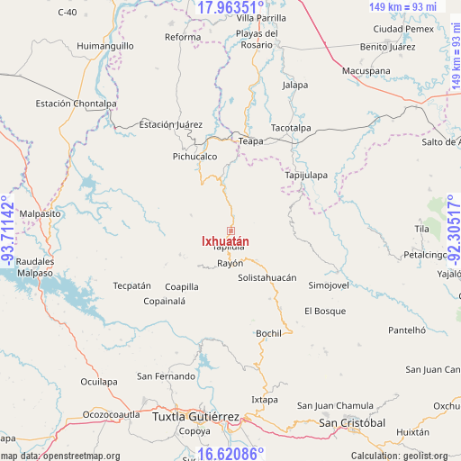
Ixhuatán GPS coordinates[2]
17° 17' 36.276" North, 93° 0' 29.844" West
| Map corner | latitude | longitude |
|---|---|---|
| Upper-left | 17.96351°, | -93.71142° |
| Center: | 17.29341°, | -93.00829° |
| Lower-right: | 16.62086°, | -92.30517° |
| Map W x H: | 149.3×149.3 km | = 92.8×92.8mi |
| max Lat: | 32.7° ⇑85.4% North |
| Ixhuatán: | 17.29341° |
| min Lat: | ⇓14.6% South 14.53588° |
| min Long | Ixhuatán | max Long |
| -117.105° | -93.00829° | -86.73105° |
| W 88.5%⇐ | ⇒11.5% E |
Elevation
Elevation of Ixhuatán is 459 m = 1506 ft, and this is 794.7 m = 2607 ft below average elevation for this country.
| Max E: |
3497 m = 11473 ft | 69.1% |
| Avg. | 1253.7 m = 4113 ft | |
| Ixhuatán | 459 m = 1506 ft | |
Min E: |
-1 m = -3 ft | 30.9% |
See also: Mexico elevation on elevation.city.
Geographical zone
Ixhuatán is located in North Torrid zone (between Equator and Tropic of Cancer). Distance of this Northern Tropic circle is 683.1 km =424.5 mi to North.| Distance of | km | miles | from Ixhuatán |
|---|---|---|---|
| North Pole | 8084.2 | 5023.3 | to North |
| Arctic Circle | 5478.3 | 3404.1 | to North |
| Tropic Cancer | 683.1 | 424.5 | to North |
| Equator | 1922.8 | 1194.8 | to South |


Nearby cities:
15 places around Ixhuatán: (largest is in red/bold)
• Cerro las Campanas
5.9 km =3.7 mi,  39°
39°
• Chapallal Grande
6.7 km =4.2 mi,  87°
87°
• El Pinabeto
10.9 km =6.8 mi,  151°
151°
• El Triunfo
9.7 km =6 mi,  209°
209°
• Ignacio Zaragoza
7.5 km =4.7 mi, 92°
• La Florida
8.1 km =5 mi,  131°
131°
• Monte Horeb
5.6 km =3.5 mi,  4°
4°
• Rayón
10.2 km =6.3 mi,  181°
181°
• Río Negro
10.8 km =6.7 mi,  294°
294°
• San Francisco Jaconá
4.3 km =2.7 mi,  217°
217°
• San Isidro las Banderas
8.9 km =5.5 mi, 218°
• Santa Anita
3.3 km =2.1 mi,  82°
82°
• Tapilula
5 km =3.1 mi,  190°
190°
• Villaflores
8.6 km =5.3 mi, 35°
• Álvaro Obregón
11 km =6.8 mi,  9°
9°
Sources, notices
• [Note1] Compared only with cities in Mexico existing in our database
• [Src1] Map data: © OpenStreetMap contributors (CC-BY-SA)
• [Src2] Other city data from geonames.org with taken over terms of usage.
• [Src3] Geographical zone / Annual Mean Temperature by Robert A. Rohde @ Wikipedia
