Monte Horeb geodata
Monte Horeb (Chiapas) is a populated place; located in Mexico in America/Mexico_City (GMT-6) time zone. With population of 580 people, there are 14779 cities with bigger population in this country. Compared to other cities in Mexico, 84.8% of cities are located further ↑North; 88.6% of cities are located further ←West and 72.8% of cities have higher elevation than Monte Horeb. Note1


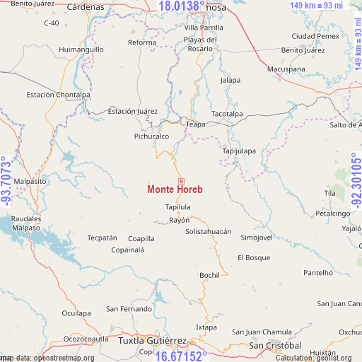
Monte Horeb GPS coordinates[2]
17° 20' 38.004" North, 93° 0' 15.012" West
| Map corner | latitude | longitude |
|---|---|---|
| Upper-left | 18.0138°, | -93.7073° |
| Center: | 17.34389°, | -93.00417° |
| Lower-right: | 16.67152°, | -92.30105° |
| Map W x H: | 149.2×149.3 km | = 92.7×92.8mi |
| max Lat: | 32.7° ⇑84.8% North |
| Monte Horeb: | 17.34389° |
| min Lat: | ⇓15.2% South 14.53588° |
| min Long | Monte Horeb | max Long |
| -117.105° | -93.00417° | -86.73105° |
| W 88.6%⇐ | ⇒11.4% E |
Elevation
Elevation of Monte Horeb is 298 m = 978 ft, and this is 955.7 m = 3135 ft below average elevation for this country.
| Max E: |
3497 m = 11473 ft | 72.8% |
| Avg. | 1253.7 m = 4113 ft | |
| Monte Horeb | 298 m = 978 ft | |
Min E: |
-1 m = -3 ft | 27.2% |
See also: Mexico elevation on elevation.city.
Geographical zone
Monte Horeb is located in North Torrid zone (between Equator and Tropic of Cancer). Distance of this Northern Tropic circle is 677.5 km =421 mi to North.| Distance of | km | miles | from Monte Horeb |
|---|---|---|---|
| North Pole | 8078.6 | 5019.8 | to North |
| Arctic Circle | 5472.7 | 3400.6 | to North |
| Tropic Cancer | 677.5 | 421 | to North |
| Equator | 1928.5 | 1198.3 | to South |


Nearby cities:
15 places around Monte Horeb: (largest is in red/bold)
• Cerro las Campanas
3.5 km =2.2 mi,  107°
107°
• Chapallal Grande
8.2 km =5.1 mi,  130°
130°
• Ignacio Zaragoza
9.2 km =5.7 mi, 130°
• Ixhuatán
5.6 km =3.5 mi,  184°
184°
• La Florida
12.3 km =7.6 mi,  152°
152°
• La Gloria
12.2 km =7.6 mi,  26°
26°
• Lázaro Cárdenas
7.7 km =4.8 mi,  57°
57°
• Río Negro
10.3 km =6.4 mi,  263°
263°
• San Francisco Jaconá
9.5 km =5.9 mi,  198°
198°
• San José Chapayal
13 km =8.1 mi, 111°
• Santa Anita
5.9 km =3.7 mi, 151°
• Solosuchiapa
10 km =6.2 mi,  342°
342°
• Tapilula
10.6 km =6.6 mi,  187°
187°
• Villaflores
4.8 km =3 mi,  73°
73°
• Álvaro Obregón
5.4 km =3.4 mi,  14°
14°
Sources, notices
• [Note1] Compared only with cities in Mexico existing in our database
• [Src1] Map data: © OpenStreetMap contributors (CC-BY-SA)
• [Src2] Other city data from geonames.org with taken over terms of usage.
• [Src3] Geographical zone / Annual Mean Temperature by Robert A. Rohde @ Wikipedia
