Tapilula geodata
Tapilula (Chiapas) is a seat of a second-order administrative division; located in Mexico in America/Mexico_City (GMT-6) time zone. With population of 7,441 people, there are 1250 cities with bigger population in this country. Compared to other cities in Mexico, 85.9% of cities are located further ↑North; 88.4% of cities are located further ←West and 63.5% of cities have higher elevation than Tapilula. Note1


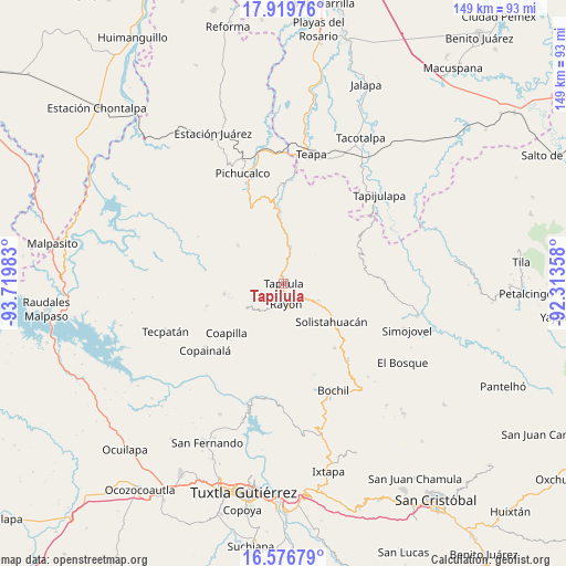
Tapilula GPS coordinates[2]
17° 14' 58.2" North, 93° 1' 0.12" West
| Map corner | latitude | longitude |
|---|---|---|
| Upper-left | 17.91976°, | -93.71983° |
| Center: | 17.2495°, | -93.0167° |
| Lower-right: | 16.57679°, | -92.31358° |
| Map W x H: | 149.3×149.3 km | = 92.8×92.8mi |
| max Lat: | 32.7° ⇑85.9% North |
| Tapilula: | 17.2495° |
| min Lat: | ⇓14.1% South 14.53588° |
| min Long | Tapilula | max Long |
| -117.105° | -93.0167° | -86.73105° |
| W 88.4%⇐ | ⇒11.6% E |
Elevation
Elevation of Tapilula is 785 m = 2575 ft, and this is 468.7 m = 1538 ft below average elevation for this country.
| Max E: |
3497 m = 11473 ft | 63.5% |
| Avg. | 1253.7 m = 4113 ft | |
| Tapilula | 785 m = 2575 ft | |
Min E: |
-1 m = -3 ft | 36.5% |
See also: Mexico elevation on elevation.city.
Geographical zone
Tapilula is located in North Torrid zone (between Equator and Tropic of Cancer). Distance of this Northern Tropic circle is 688 km =427.5 mi to North.| Distance of | km | miles | from Tapilula |
|---|---|---|---|
| North Pole | 8089.1 | 5026.3 | to North |
| Arctic Circle | 5483.2 | 3407.1 | to North |
| Tropic Cancer | 688 | 427.5 | to North |
| Equator | 1918 | 1191.8 | to South |


Nearby cities:
15 places around Tapilula: (largest is in red/bold)
• Cerro las Campanas
10.5 km =6.5 mi,  26°
26°
• Chapallal Grande
9.2 km =5.7 mi,  55°
55°
• El Pinabeto
7.7 km =4.8 mi,  127°
127°
• El Triunfo
5.3 km =3.3 mi,  227°
227°
• Ignacio Zaragoza
9.5 km =5.9 mi, 61°
• Ixhuatán
5 km =3.1 mi,  10°
10°
• La Florida
7 km =4.3 mi,  93°
93°
• Monte Horeb
10.6 km =6.6 mi, 7°
• Pantepec
7.7 km =4.8 mi,  207°
207°
• Rayón
5.4 km =3.4 mi,  173°
173°
• Rincón Chamula
9.5 km =5.9 mi,  119°
119°
• San Francisco Jaconá
2.2 km =1.4 mi,  311°
311°
• San Isidro las Banderas
5.1 km =3.2 mi,  245°
245°
• Santa Anita
6.7 km =4.2 mi,  37°
37°
• Tapalapa
11.4 km =7.1 mi,  235°
235°
Sources, notices
• [Note1] Compared only with cities in Mexico existing in our database
• [Src1] Map data: © OpenStreetMap contributors (CC-BY-SA)
• [Src2] Other city data from geonames.org with taken over terms of usage.
• [Src3] Geographical zone / Annual Mean Temperature by Robert A. Rohde @ Wikipedia
