El Triunfo geodata
El Triunfo (Chiapas) is a populated place; located in Mexico in America/Mexico_City (GMT-6) time zone. With population of 734 people, there are 11902 cities with bigger population in this country. Compared to other cities in Mexico, 86.3% of cities are located further ↑North; 88.3% of cities are located further ←West and 51.6% of cities have lower elevation than El Triunfo. Note1


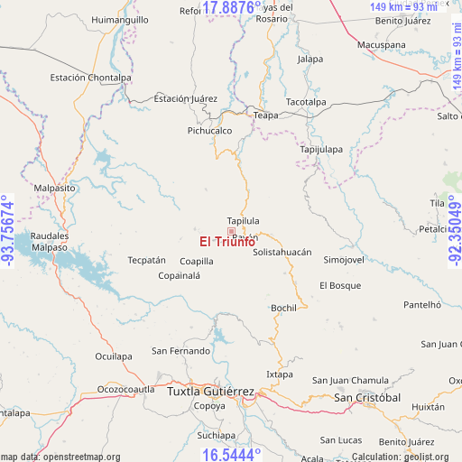
El Triunfo GPS coordinates[2]
17° 13' 1.992" North, 93° 3' 12.996" West
| Map corner | latitude | longitude |
|---|---|---|
| Upper-left | 17.8876°, | -93.75674° |
| Center: | 17.21722°, | -93.05361° |
| Lower-right: | 16.5444°, | -92.35049° |
| Map W x H: | 149.3×149.4 km | = 92.8×92.8mi |
| max Lat: | 32.7° ⇑86.3% North |
| El Triunfo: | 17.21722° |
| min Lat: | ⇓13.7% South 14.53588° |
| min Long | El Triunfo | max Long |
| -117.105° | -93.05361° | -86.73105° |
| W 88.3%⇐ | ⇒11.7% E |
Elevation
Elevation of El Triunfo is 1509 m = 4951 ft, and this is 255.3 m = 838 ft above average elevation for this country.
| Max E: |
3497 m = 11473 ft | 48.4% |
| El Triunfo | 1509 m 4951 ft | |
| Avg. | 1253.7 m = 4113 ft | |
Min E: |
-1 m = -3 ft | 51.6% |
See also: Mexico elevation on elevation.city.
Geographical zone
El Triunfo is located in North Torrid zone (between Equator and Tropic of Cancer). Distance of this Northern Tropic circle is 691.5 km =429.7 mi to North.| Distance of | km | miles | from El Triunfo |
|---|---|---|---|
| North Pole | 8092.7 | 5028.6 | to North |
| Arctic Circle | 5486.8 | 3409.3 | to North |
| Tropic Cancer | 691.5 | 429.7 | to North |
| Equator | 1914.4 | 1189.6 | to South |


Nearby cities:
15 places around El Triunfo: (largest is in red/bold)
• El Amate
11.6 km =7.2 mi,  153°
153°
• El Carrizal
6.6 km =4.1 mi,  202°
202°
• El Pinabeto
10.1 km =6.3 mi,  96°
96°
• Ixhuatán
9.7 km =6 mi,  29°
29°
• La Florida
11.3 km =7 mi,  73°
73°
• Ocotepec
11.8 km =7.3 mi,  274°
274°
• Pantepec
3.2 km =2 mi,  173°
173°
• Rayón
4.8 km =3 mi,  111°
111°
• San Andrés Carrizal
9.5 km =5.9 mi, 269°
• San Francisco Jaconá
5.5 km =3.4 mi,  23°
23°
• San Francisco Ocotal
10.2 km =6.3 mi, 269°
• San Isidro las Banderas
1.6 km =1 mi,  333°
333°
• Tapalapa
6.2 km =3.9 mi,  242°
242°
• Tapilula
5.3 km =3.3 mi,  47°
47°
• Vicente Guerrero
9.5 km =5.9 mi,  184°
184°
Sources, notices
• [Note1] Compared only with cities in Mexico existing in our database
• [Src1] Map data: © OpenStreetMap contributors (CC-BY-SA)
• [Src2] Other city data from geonames.org with taken over terms of usage.
• [Src3] Geographical zone / Annual Mean Temperature by Robert A. Rohde @ Wikipedia
