Hueypoxtla geodata
Hueypoxtla (State of Mexico) is a seat of a second-order administrative division; located in Mexico in America/Mexico_City (GMT-6) time zone. With population of 3,989 people, there are 2285 cities with bigger population in this country. Compared to other cities in Mexico, 55.3% of cities are located further ↓South; 50.8% of cities are located further →East and 85.7% of cities have lower elevation than Hueypoxtla. Note1


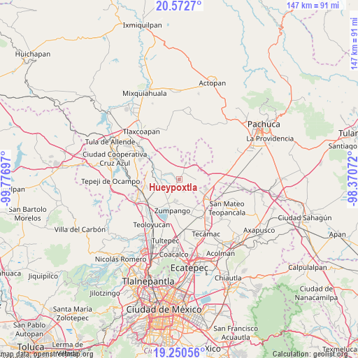
Hueypoxtla GPS coordinates[2]
19° 54' 46.836" North, 99° 4' 25.824" West
| Map corner | latitude | longitude |
|---|---|---|
| Upper-left | 20.5727°, | -99.77697° |
| Center: | 19.91301°, | -99.07384° |
| Lower-right: | 19.25056°, | -98.37072° |
| Map W x H: | 147×147 km | = 91.3×91.3mi |
| max Lat: | 32.7° ⇑44.7% North |
| Hueypoxtla: | 19.91301° |
| min Lat: | ⇓55.3% South 14.53588° |
| min Long | Hueypoxtla | max Long |
| -117.105° | -99.07384° | -86.73105° |
| W 49.2%⇐ | ⇒50.8% E |
Elevation
Elevation of Hueypoxtla is 2275 m = 7464 ft, and this is 1021.3 m = 3351 ft above average elevation for this country.
| Max E: |
3497 m = 11473 ft | 14.3% |
| Hueypoxtla | 2275 m 7464 ft | |
| Avg. | 1253.7 m = 4113 ft | |
Min E: |
-1 m = -3 ft | 85.7% |
See also: Mexico elevation on elevation.city.
Geographical zone
Hueypoxtla is located in North Torrid zone (between Equator and Tropic of Cancer). Distance of this Northern Tropic circle is 391.8 km =243.5 mi to North.| Distance of | km | miles | from Hueypoxtla |
|---|---|---|---|
| North Pole | 7792.9 | 4842.3 | to North |
| Arctic Circle | 5187.1 | 3223.1 | to North |
| Tropic Cancer | 391.8 | 243.5 | to North |
| Equator | 2214.1 | 1375.8 | to South |


Nearby cities:
15 places around Hueypoxtla: (largest is in red/bold)
• Barrio de España
5.8 km =3.6 mi,  188°
188°
• Barrio el Rincón
4.4 km =2.7 mi, 189°
• Colonia Guadalupe los Manantiales
7.9 km =4.9 mi,  11°
11°
• Emiliano Zapata (San José Bata)
7 km =4.3 mi,  91°
91°
• Jilotzingo
5.1 km =3.2 mi,  165°
165°
• Loma Larga (Barrio de Loma Larga)
6.7 km =4.2 mi,  220°
220°
• Miguel Bocanegra
8.5 km =5.3 mi,  208°
208°
• Oriental de Zapata
9.2 km =5.7 mi,  28°
28°
• San Miguel
8 km =5 mi,  232°
232°
• San Miguel Bocanegra
8.6 km =5.3 mi, 207°
• Santa María Ajoloapan
7.7 km =4.8 mi,  23°
23°
• Santa María Cuevas
5.8 km =3.6 mi, 206°
• Tequixquiac
7.4 km =4.6 mi,  266°
266°
• Tlapanaloya
3.5 km =2.2 mi,  317°
317°
• Villas de la Laguna
8.7 km =5.4 mi, 191°
Sources, notices
• [Note1] Compared only with cities in Mexico existing in our database
• [Src1] Map data: © OpenStreetMap contributors (CC-BY-SA)
• [Src2] Other city data from geonames.org with taken over terms of usage.
• [Src3] Geographical zone / Annual Mean Temperature by Robert A. Rohde @ Wikipedia
