Hueyotlipan geodata
Hueyotlipan (Tlaxcala) is a seat of a second-order administrative division; located in Mexico in America/Mexico_City (GMT-6) time zone. With population of 4,911 people, there are 1884 cities with bigger population in this country. Compared to other cities in Mexico, 54.7% of cities are located further ↑North; 59.3% of cities are located further ←West and 94.3% of cities have lower elevation than Hueyotlipan. Note1


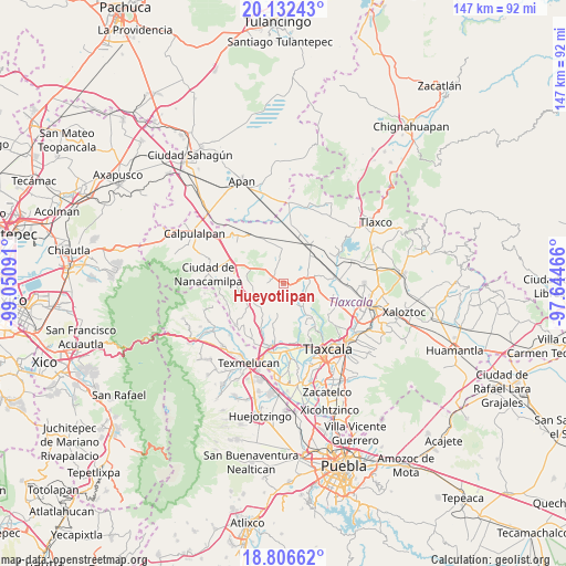
Hueyotlipan GPS coordinates[2]
19° 28' 15.168" North, 98° 20' 52.008" West
| Map corner | latitude | longitude |
|---|---|---|
| Upper-left | 20.13243°, | -99.05091° |
| Center: | 19.47088°, | -98.34778° |
| Lower-right: | 18.80662°, | -97.64466° |
| Map W x H: | 147.4×147.4 km | = 91.6×91.6mi |
| max Lat: | 32.7° ⇑54.7% North |
| Hueyotlipan: | 19.47088° |
| min Lat: | ⇓45.3% South 14.53588° |
| min Long | Hueyotlipan | max Long |
| -117.105° | -98.34778° | -86.73105° |
| W 59.3%⇐ | ⇒40.7% E |
Elevation
Elevation of Hueyotlipan is 2580 m = 8465 ft, and this is 1326.3 m = 4351 ft above average elevation for this country.
| Max E: |
3497 m = 11473 ft | 5.7% |
| Hueyotlipan | 2580 m 8465 ft | |
| Avg. | 1253.7 m = 4113 ft | |
Min E: |
-1 m = -3 ft | 94.3% |
See also: Mexico elevation on elevation.city.
Geographical zone
Hueyotlipan is located in North Torrid zone (between Equator and Tropic of Cancer). Distance of this Northern Tropic circle is 441 km =274 mi to North.| Distance of | km | miles | from Hueyotlipan |
|---|---|---|---|
| North Pole | 7842.1 | 4872.9 | to North |
| Arctic Circle | 5236.2 | 3253.6 | to North |
| Tropic Cancer | 441 | 274 | to North |
| Equator | 2165 | 1345.3 | to South |


Nearby cities:
15 places around Hueyotlipan: (largest is in red/bold)
• Españita
8.1 km =5 mi,  263°
263°
• Guadalupe Cuauhtémoc
12.6 km =7.8 mi,  65°
65°
• Huiloapan
12.4 km =7.7 mi,  138°
138°
• Ignacio Zaragoza
11.4 km =7.1 mi,  343°
343°
• La Magdalena Cuextotitla
10.4 km =6.5 mi,  268°
268°
• La Magdalena Soltepec
12.7 km =7.9 mi,  16°
16°
• San Francisco Mitepec
11.1 km =6.9 mi,  251°
251°
• San José Cuamantzingo
11 km =6.8 mi,  63°
63°
• San Lucas Tecopilco
9.8 km =6.1 mi,  79°
79°
• San Marcos Jilotepec
10.7 km =6.6 mi,  195°
195°
• San Simeón Xipetzingo
5.8 km =3.6 mi, 79°
• Sanctórum
13.2 km =8.2 mi,  280°
280°
• Santa Bárbara Acuicultzcatepec
13.3 km =8.3 mi,  102°
102°
• Santa María Ixcotla
6.1 km =3.8 mi,  148°
148°
• Santiago Tlalpan
4.1 km =2.5 mi, 80°
Sources, notices
• [Note1] Compared only with cities in Mexico existing in our database
• [Src1] Map data: © OpenStreetMap contributors (CC-BY-SA)
• [Src2] Other city data from geonames.org with taken over terms of usage.
• [Src3] Geographical zone / Annual Mean Temperature by Robert A. Rohde @ Wikipedia
