La Magdalena Cuextotitla geodata
La Magdalena Cuextotitla (Tlaxcala) is a populated place; located in Mexico in America/Mexico_City (GMT-6) time zone. With population of 924 people, there are 9451 cities with bigger population in this country. Compared to other cities in Mexico, 54.7% of cities are located further ↑North; 58% of cities are located further ←West and 97% of cities have lower elevation than La Magdalena Cuextotitla. Note1
Current local time in La Magdalena Cuextotitla:
06:51 AM, WednesdayDifference from your time zone: hours


La Magdalena Cuextotitla GPS coordinates[2]
19° 28' 9.084" North, 98° 26' 49.848" West
| Map corner | latitude | longitude |
|---|---|---|
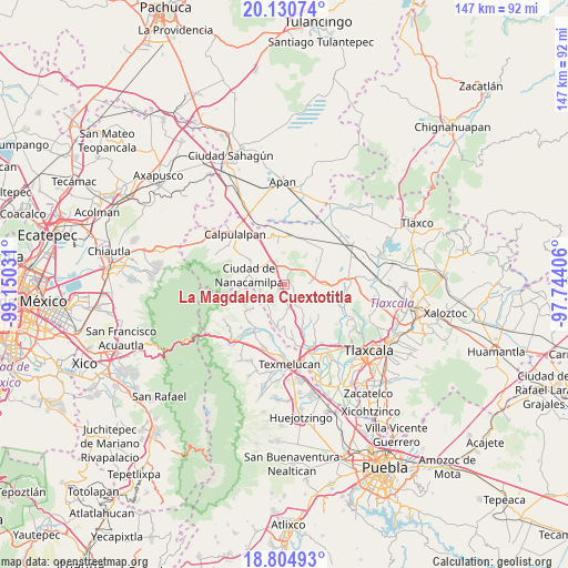
| Upper-left | 20.13074°, | -99.15031° |
| Center: | 19.46919°, | -98.44718° |
| Lower-right: | 18.80493°, | -97.74406° |
| Map W x H: | 147.4×147.4 km | = 91.6×91.6mi |
| max Lat: | 32.7° ⇑54.7% North |
| La Magdalena Cuextotitla: | 19.46919° |
| min Lat: | ⇓45.3% South 14.53588° |
| min Long | La Magdalena Cu | max Long |
| -117.105° | -98.44718° | -86.73105° |
| W 58%⇐ | ⇒42% E |
Elevation
Elevation of La Magdalena Cuextotitla is 2681 m = 8796 ft, and this is 1427.3 m = 4683 ft above average elevation for this country.
| Max E: |
3497 m = 11473 ft | 3% |
| La Magdalena Cuextotitla | 2681 m 8796 ft | |
| Avg. | 1253.7 m = 4113 ft | |
Min E: |
-1 m = -3 ft | 97% |
See also: Mexico elevation on elevation.city.
Geographical zone
La Magdalena Cuextotitla is located in North Torrid zone (between Equator and Tropic of Cancer). Distance of this Northern Tropic circle is 441.1 km =274.1 mi to North.| Distance of | km | miles | from La Magdalena Cuextotitla |
|---|---|---|---|
| North Pole | 7842.3 | 4873 | to North |
| Arctic Circle | 5236.4 | 3253.7 | to North |
| Tropic Cancer | 441.1 | 274.1 | to North |
| Equator | 2164.8 | 1345.1 | to South |


Nearby cities:
15 places around La Magdalena Cuextotitla: (largest is in red/bold)
• Alpotzonga de Lira y Ortega
11 km =6.8 mi,  172°
172°
• Ciudad de Nanacamilpa
9.8 km =6.1 mi,  286°
286°
• Domingo Arenas (La Calera)
6 km =3.7 mi,  331°
331°
• Españita
2.5 km =1.6 mi,  106°
106°
• Francisco I. Madero
7.3 km =4.5 mi,  321°
321°
• Guadalupito las Dalias
10.1 km =6.3 mi,  234°
234°
• Hueyotlipan
10.4 km =6.5 mi,  88°
88°
• La Preciosita
12.2 km =7.6 mi,  236°
236°
• San Antonio Atotonilco
10.7 km =6.6 mi,  190°
190°
• San Felipe Hidalgo
11.7 km =7.3 mi,  269°
269°
• San Francisco Mitepec
3.3 km =2.1 mi,  181°
181°
• San Francisco Tláloc
11.5 km =7.1 mi,  195°
195°
• Sanctórum
3.7 km =2.3 mi, 316°
• Santa Cruz Moxolahuac
10.5 km =6.5 mi,  256°
256°
• Vicente Guerrero
6.9 km =4.3 mi,  220°
220°
Sources, notices
• [Note1] Compared only with cities in Mexico existing in our database
• [Src1] Map data: © OpenStreetMap contributors (CC-BY-SA)
• [Src2] Other city data from geonames.org with taken over terms of usage.
• [Src3] Geographical zone / Annual Mean Temperature by Robert A. Rohde @ Wikipedia
