Tandzumadz geodata
Tandzumadz (San Luis Potosí) is a populated place; located in Mexico in America/Mexico_City (GMT-6) time zone. With population of 1,377 people, there are 6298 cities with bigger population in this country. Compared to other cities in Mexico, 81.8% of cities are located further ↓South; 50.5% of cities are located further ←West and 69.6% of cities have higher elevation than Tandzumadz. Note1


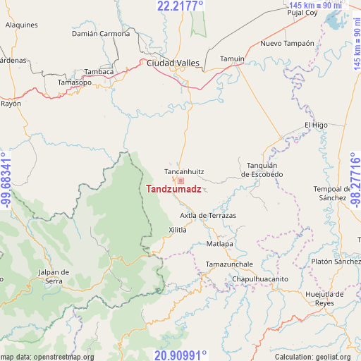
Tandzumadz GPS coordinates[2]
21° 33' 55.008" North, 98° 58' 49.008" West
| Map corner | latitude | longitude |
|---|---|---|
| Upper-left | 22.2177°, | -99.68341° |
| Center: | 21.56528°, | -98.98028° |
| Lower-right: | 20.90991°, | -98.27716° |
| Map W x H: | 145.4×145.4 km | = 90.3×90.3mi |
| max Lat: | 32.7° ⇑18.2% North |
| Tandzumadz: | 21.56528° |
| min Lat: | ⇓81.8% South 14.53588° |
| min Long | Tandzumadz | max Long |
| -117.105° | -98.98028° | -86.73105° |
| W 50.5%⇐ | ⇒49.5% E |
Elevation
Elevation of Tandzumadz is 435 m = 1427 ft, and this is 818.7 m = 2686 ft below average elevation for this country.
| Max E: |
3497 m = 11473 ft | 69.6% |
| Avg. | 1253.7 m = 4113 ft | |
| Tandzumadz | 435 m = 1427 ft | |
Min E: |
-1 m = -3 ft | 30.4% |
See also: Mexico elevation on elevation.city.
Geographical zone
Tandzumadz is located in North Torrid zone (between Equator and Tropic of Cancer). Distance of this Northern Tropic circle is 208.1 km =129.3 mi to North.| Distance of | km | miles | from Tandzumadz |
|---|---|---|---|
| North Pole | 7609.2 | 4728.1 | to North |
| Arctic Circle | 5003.3 | 3108.9 | to North |
| Tropic Cancer | 208.1 | 129.3 | to North |
| Equator | 2397.8 | 1489.9 | to South |


Nearby cities:
15 places around Tandzumadz: (largest is in red/bold)
• Aquismón
7.5 km =4.7 mi,  326°
326°
• Cruz Blanca
3.6 km =2.2 mi,  220°
220°
• Huehuetlán
2.5 km =1.6 mi,  148°
148°
• Jilim Tantocoy Tres
5.4 km =3.4 mi,  191°
191°
• La Escalera
6.3 km =3.9 mi,  203°
203°
• La Pimienta
5 km =3.1 mi,  213°
213°
• Lanim
5.6 km =3.5 mi, 333°
• San José Pequetzén
7.5 km =4.7 mi,  16°
16°
• Santa Bárbara
3 km =1.9 mi,  277°
277°
• Tamcuime
5.1 km =3.2 mi,  321°
321°
• Tampuchón
6.8 km =4.2 mi, 154°
• Tancanhuitz
3.9 km =2.4 mi, 19°
• Tanleab Uno
3.5 km =2.2 mi,  135°
135°
• Tantocoy Uno
4 km =2.5 mi, 196°
• Tzinejá Uno
1.4 km =0.9 mi,  83°
83°
Sources, notices
• [Note1] Compared only with cities in Mexico existing in our database
• [Src1] Map data: © OpenStreetMap contributors (CC-BY-SA)
• [Src2] Other city data from geonames.org with taken over terms of usage.
• [Src3] Geographical zone / Annual Mean Temperature by Robert A. Rohde @ Wikipedia
