Horcones geodata
Horcones (Veracruz) is a populated place; located in Mexico in America/Mexico_City (GMT-6) time zone. With population of 812 people, there are 10760 cities with bigger population in this country. Compared to other cities in Mexico, 77.5% of cities are located further ↓South; 66.7% of cities are located further ←West and 82.1% of cities have higher elevation than Horcones. Note1


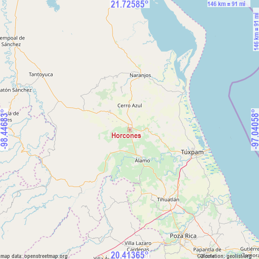
Horcones GPS coordinates[2]
21° 4' 16.32" North, 97° 44' 37.32" West
| Map corner | latitude | longitude |
|---|---|---|
| Upper-left | 21.72585°, | -98.44683° |
| Center: | 21.0712°, | -97.7437° |
| Lower-right: | 20.41365°, | -97.04058° |
| Map W x H: | 145.9×145.9 km | = 90.7×90.7mi |
| max Lat: | 32.7° ⇑22.5% North |
| Horcones: | 21.0712° |
| min Lat: | ⇓77.5% South 14.53588° |
| min Long | Horcones | max Long |
| -117.105° | -97.7437° | -86.73105° |
| W 66.7%⇐ | ⇒33.3% E |
Elevation
Elevation of Horcones is 69 m = 226 ft, and this is 1184.7 m = 3887 ft below average elevation for this country.
| Max E: |
3497 m = 11473 ft | 82.1% |
| Avg. | 1253.7 m = 4113 ft | |
| Horcones | 69 m = 226 ft | |
Min E: |
-1 m = -3 ft | 17.9% |
See also: Mexico elevation on elevation.city.
Geographical zone
Horcones is located in North Torrid zone (between Equator and Tropic of Cancer). Distance of this Northern Tropic circle is 263 km =163.4 mi to North.| Distance of | km | miles | from Horcones |
|---|---|---|---|
| North Pole | 7664.2 | 4762.3 | to North |
| Arctic Circle | 5058.3 | 3143.1 | to North |
| Tropic Cancer | 263 | 163.4 | to North |
| Equator | 2342.9 | 1455.8 | to South |


Nearby cities:
15 places around Horcones: (largest is in red/bold)
• Cerro Azul
13.4 km =8.3 mi,  1°
1°
• Estación Chapapote (Puerta Siete)
13.9 km =8.6 mi,  171°
171°
• General A. Tejeda y su A. Graciano Sánchez
13.2 km =8.2 mi,  162°
162°
• Juan Felipe
9.6 km =6 mi,  344°
344°
• La Guásima
10.8 km =6.7 mi,  295°
295°
• Monte Chiquito
13.4 km =8.3 mi,  206°
206°
• Ojital Ciruelo
13.4 km =8.3 mi,  177°
177°
• Ojital Santa María
13.2 km =8.2 mi, 183°
• Piedra Labrada
14.7 km =9.1 mi, 339°
• Potrero del Llano
1.9 km =1.2 mi,  59°
59°
• Puerta Siete
14.9 km =9.3 mi, 162°
• Temapache
10.6 km =6.6 mi,  93°
93°
• Tierra Blanca Booxter
8.9 km =5.5 mi, 161°
• Vara Alta
11 km =6.8 mi,  139°
139°
• Zapotitlán
8.7 km =5.4 mi, 301°
Sources, notices
• [Note1] Compared only with cities in Mexico existing in our database
• [Src1] Map data: © OpenStreetMap contributors (CC-BY-SA)
• [Src2] Other city data from geonames.org with taken over terms of usage.
• [Src3] Geographical zone / Annual Mean Temperature by Robert A. Rohde @ Wikipedia
