Hidalgo geodata
Hidalgo (Chiapas) is a populated place; located in Mexico in America/Mexico_City (GMT-6) time zone. With population of 1,209 people, there are 7199 cities with bigger population in this country. Compared to other cities in Mexico, 98.8% of cities are located further ↑North; 90.2% of cities are located further ←West and 84.1% of cities have higher elevation than Hidalgo. Note1


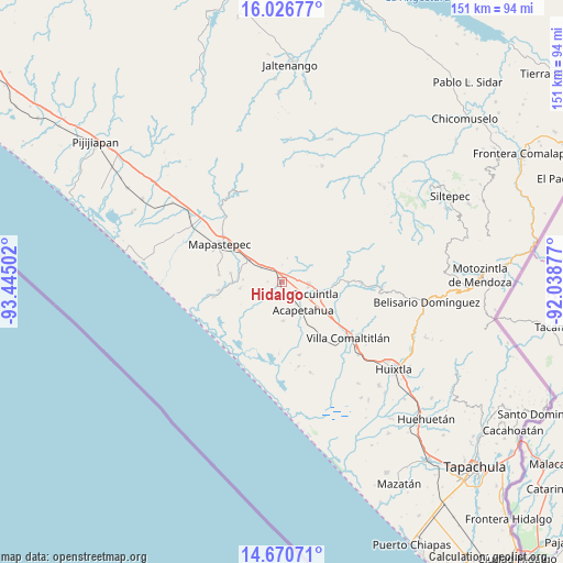
Hidalgo GPS coordinates[2]
15° 20' 59.424" North, 92° 44' 30.804" West
| Map corner | latitude | longitude |
|---|---|---|
| Upper-left | 16.02677°, | -93.44502° |
| Center: | 15.34984°, | -92.74189° |
| Lower-right: | 14.67071°, | -92.03877° |
| Map W x H: | 150.8×150.8 km | = 93.7×93.7mi |
| max Lat: | 32.7° ⇑98.8% North |
| Hidalgo: | 15.34984° |
| min Lat: | ⇓1.2% South 14.53588° |
| min Long | Hidalgo | max Long |
| -117.105° | -92.74189° | -86.73105° |
| W 90.2%⇐ | ⇒9.8% E |
Elevation
Elevation of Hidalgo is 51 m = 167 ft, and this is 1202.7 m = 3946 ft below average elevation for this country.
| Max E: |
3497 m = 11473 ft | 84.1% |
| Avg. | 1253.7 m = 4113 ft | |
| Hidalgo | 51 m = 167 ft | |
Min E: |
-1 m = -3 ft | 15.9% |
See also: Mexico elevation on elevation.city.
Geographical zone
Hidalgo is located in North Torrid zone (between Equator and Tropic of Cancer). Distance of this Northern Tropic circle is 899.2 km =558.7 mi to North.| Distance of | km | miles | from Hidalgo |
|---|---|---|---|
| North Pole | 8300.3 | 5157.6 | to North |
| Arctic Circle | 5694.4 | 3538.3 | to North |
| Tropic Cancer | 899.2 | 558.7 | to North |
| Equator | 1706.7 | 1060.5 | to South |


Nearby cities:
15 places around Hidalgo: (largest is in red/bold)
• Acacoyagua
7.2 km =4.5 mi,  98°
98°
• Acapetahua
9.4 km =5.8 mi,  143°
143°
• El Consuelo Ulapa
6.8 km =4.2 mi,  307°
307°
• El Madronal
8.3 km =5.2 mi,  153°
153°
• Escuintla
9.6 km =6 mi,  110°
110°
• Jalapa
6.5 km =4 mi,  84°
84°
• Jiquilpan
7.4 km =4.6 mi,  246°
246°
• Jiquilpan (Estación Bonanza)
1.1 km =0.7 mi,  214°
214°
• Las Cruces
7.8 km =4.8 mi,  170°
170°
• Los Amates
5.2 km =3.2 mi,  94°
94°
• Los Cacaos
10.1 km =6.3 mi,  64°
64°
• Nueva Libertad
7.4 km =4.6 mi,  31°
31°
• Nueva Sesecapa
10.4 km =6.5 mi,  303°
303°
• Soconusco
4.2 km =2.6 mi,  156°
156°
• Veinte de Abril
9.8 km =6.1 mi, 214°
Sources, notices
• [Note1] Compared only with cities in Mexico existing in our database
• [Src1] Map data: © OpenStreetMap contributors (CC-BY-SA)
• [Src2] Other city data from geonames.org with taken over terms of usage.
• [Src3] Geographical zone / Annual Mean Temperature by Robert A. Rohde @ Wikipedia
