Guadalupe Fresnal geodata
Guadalupe Fresnal (Puebla) is a populated place; located in Mexico in America/Mexico_City (GMT-6) time zone. With population of 580 people, there are 14779 cities with bigger population in this country. Compared to other cities in Mexico, 69.2% of cities are located further ↑North; 71% of cities are located further ←West and 92.2% of cities have lower elevation than Guadalupe Fresnal. Note1


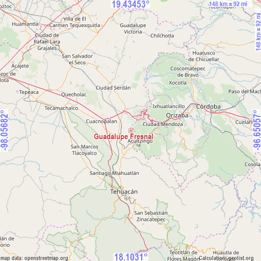
Guadalupe Fresnal GPS coordinates[2]
18° 46' 12.468" North, 97° 21' 13.284" West
| Map corner | latitude | longitude |
|---|---|---|
| Upper-left | 19.43453°, | -98.05682° |
| Center: | 18.77013°, | -97.35369° |
| Lower-right: | 18.1031°, | -96.65057° |
| Map W x H: | 148×148 km | = 92×92mi |
| max Lat: | 32.7° ⇑69.2% North |
| Guadalupe Fresnal: | 18.77013° |
| min Lat: | ⇓30.8% South 14.53588° |
| min Long | Guadalupe Fresn | max Long |
| -117.105° | -97.35369° | -86.73105° |
| W 71%⇐ | ⇒29% E |
Elevation
Elevation of Guadalupe Fresnal is 2493 m = 8179 ft, and this is 1239.3 m = 4066 ft above average elevation for this country.
| Max E: |
3497 m = 11473 ft | 7.8% |
| Guadalupe Fresnal | 2493 m 8179 ft | |
| Avg. | 1253.7 m = 4113 ft | |
Min E: |
-1 m = -3 ft | 92.2% |
See also: Mexico elevation on elevation.city.
Geographical zone
Guadalupe Fresnal is located in North Torrid zone (between Equator and Tropic of Cancer). Distance of this Northern Tropic circle is 518.9 km =322.4 mi to North.| Distance of | km | miles | from Guadalupe Fresnal |
|---|---|---|---|
| North Pole | 7920 | 4921.3 | to North |
| Arctic Circle | 5314.1 | 3302 | to North |
| Tropic Cancer | 518.9 | 322.4 | to North |
| Equator | 2087 | 1296.8 | to South |


Nearby cities:
15 places around Guadalupe Fresnal: (largest is in red/bold)
• Acultzingo
7.8 km =4.8 mi,  137°
137°
• Aquila
5.5 km =3.4 mi,  59°
59°
• Barrio la Soledad
6.9 km =4.3 mi,  294°
294°
• Boca Nopal
1.5 km =0.9 mi,  172°
172°
• Buena Vista
3.7 km =2.3 mi,  219°
219°
• Cerro Gordo
6.3 km =3.9 mi, 222°
• Guadalupe Piletas
8.4 km =5.2 mi,  309°
309°
• Huiloapan
4.5 km =2.8 mi,  119°
119°
• Los Garcías
5.6 km =3.5 mi, 310°
• Morelos Cañada
8 km =5 mi,  241°
241°
• Puente Colorado
7.4 km =4.6 mi,  185°
185°
• Puerta Cañada
7.7 km =4.8 mi, 310°
• San Antonio Soledad
5.9 km =3.7 mi, 285°
• Temaxcalapa
1.9 km =1.2 mi,  230°
230°
• Tezuapan (San Isidro)
5.5 km =3.4 mi,  262°
262°
Sources, notices
• [Note1] Compared only with cities in Mexico existing in our database
• [Src1] Map data: © OpenStreetMap contributors (CC-BY-SA)
• [Src2] Other city data from geonames.org with taken over terms of usage.
• [Src3] Geographical zone / Annual Mean Temperature by Robert A. Rohde @ Wikipedia
