Temaxcalapa geodata
Temaxcalapa (Puebla) is a populated place; located in Mexico in America/Mexico_City (GMT-6) time zone. With population of 527 people, there are 16037 cities with bigger population in this country. Compared to other cities in Mexico, 69.3% of cities are located further ↑North; 70.9% of cities are located further ←West and 92.7% of cities have lower elevation than Temaxcalapa. Note1


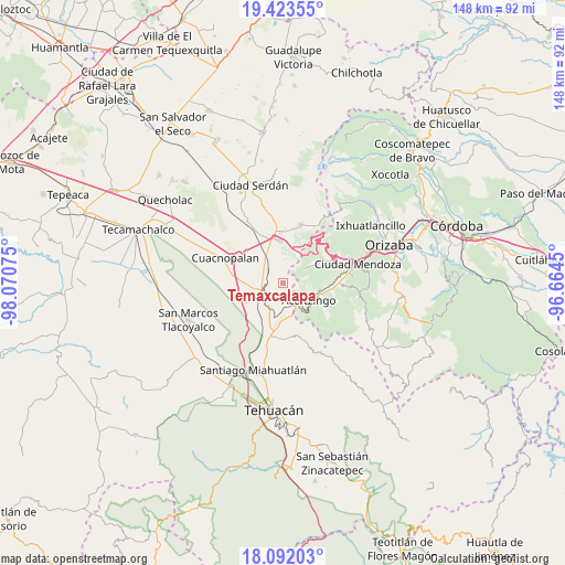
Temaxcalapa GPS coordinates[2]
18° 45' 32.76" North, 97° 22' 3.432" West
| Map corner | latitude | longitude |
|---|---|---|
| Upper-left | 19.42355°, | -98.07075° |
| Center: | 18.7591°, | -97.36762° |
| Lower-right: | 18.09203°, | -96.6645° |
| Map W x H: | 148.1×148.1 km | = 92×92mi |
| max Lat: | 32.7° ⇑69.3% North |
| Temaxcalapa: | 18.7591° |
| min Lat: | ⇓30.7% South 14.53588° |
| min Long | Temaxcalapa | max Long |
| -117.105° | -97.36762° | -86.73105° |
| W 70.9%⇐ | ⇒29.1% E |
Elevation
Elevation of Temaxcalapa is 2516 m = 8255 ft, and this is 1262.3 m = 4141 ft above average elevation for this country.
| Max E: |
3497 m = 11473 ft | 7.3% |
| Temaxcalapa | 2516 m 8255 ft | |
| Avg. | 1253.7 m = 4113 ft | |
Min E: |
-1 m = -3 ft | 92.7% |
See also: Mexico elevation on elevation.city.
Geographical zone
Temaxcalapa is located in North Torrid zone (between Equator and Tropic of Cancer). Distance of this Northern Tropic circle is 520.1 km =323.2 mi to North.| Distance of | km | miles | from Temaxcalapa |
|---|---|---|---|
| North Pole | 7921.2 | 4922 | to North |
| Arctic Circle | 5315.4 | 3302.8 | to North |
| Tropic Cancer | 520.1 | 323.2 | to North |
| Equator | 2085.8 | 1296.1 | to South |


Nearby cities:
15 places around Temaxcalapa: (largest is in red/bold)
• Acultzingo
8.1 km =5 mi,  123°
123°
• Aquila
7.4 km =4.6 mi,  56°
56°
• Barrio la Soledad
6.3 km =3.9 mi,  310°
310°
• Boca Nopal
1.7 km =1.1 mi,  100°
100°
• Buena Vista
1.9 km =1.2 mi,  208°
208°
• Cerro Gordo
4.4 km =2.7 mi,  219°
219°
• Guadalupe Fresnal
1.9 km =1.2 mi,  50°
50°
• Guadalupe Piletas
8.3 km =5.2 mi,  322°
322°
• Huiloapan
5.5 km =3.4 mi, 100°
• Los Garcías
5.7 km =3.5 mi,  330°
330°
• Morelos Cañada
6.2 km =3.9 mi,  244°
244°
• Puente Colorado
6.1 km =3.8 mi,  173°
173°
• Puerta Cañada
7.6 km =4.7 mi, 324°
• San Antonio Soledad
5 km =3.1 mi,  303°
303°
• Tezuapan (San Isidro)
4 km =2.5 mi,  277°
277°
Sources, notices
• [Note1] Compared only with cities in Mexico existing in our database
• [Src1] Map data: © OpenStreetMap contributors (CC-BY-SA)
• [Src2] Other city data from geonames.org with taken over terms of usage.
• [Src3] Geographical zone / Annual Mean Temperature by Robert A. Rohde @ Wikipedia
