Guadalupe Maravillas geodata
Guadalupe Maravillas (Chiapas) is a populated place; located in Mexico in America/Mexico_City (GMT-6) time zone. With population of 533 people, there are 15888 cities with bigger population in this country. Compared to other cities in Mexico, 97.4% of cities are located further ↑North; 92.2% of cities are located further ←West and 67.1% of cities have higher elevation than Guadalupe Maravillas. Note1


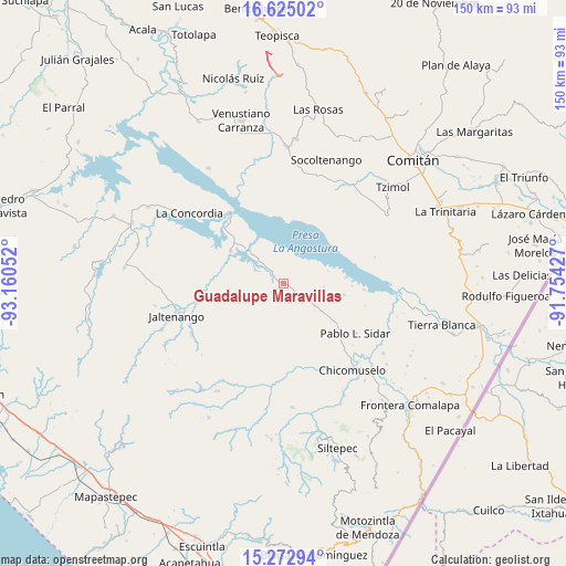
Guadalupe Maravillas GPS coordinates[2]
15° 57' 0.432" North, 92° 27' 26.604" West
| Map corner | latitude | longitude |
|---|---|---|
| Upper-left | 16.62502°, | -93.16052° |
| Center: | 15.95012°, | -92.45739° |
| Lower-right: | 15.27294°, | -91.75427° |
| Map W x H: | 150.3×150.3 km | = 93.4×93.4mi |
| max Lat: | 32.7° ⇑97.4% North |
| Guadalupe Maravillas: | 15.95012° |
| min Lat: | ⇓2.6% South 14.53588° |
| min Long | Guadalupe Marav | max Long |
| -117.105° | -92.45739° | -86.73105° |
| W 92.2%⇐ | ⇒7.8% E |
Elevation
Elevation of Guadalupe Maravillas is 578 m = 1896 ft, and this is 675.7 m = 2217 ft below average elevation for this country.
| Max E: |
3497 m = 11473 ft | 67.1% |
| Avg. | 1253.7 m = 4113 ft | |
| Guadalupe Maravillas | 578 m = 1896 ft | |
Min E: |
-1 m = -3 ft | 32.9% |
See also: Mexico elevation on elevation.city.
Geographical zone
Guadalupe Maravillas is located in North Torrid zone (between Equator and Tropic of Cancer). Distance of this Northern Tropic circle is 832.4 km =517.2 mi to North.| Distance of | km | miles | from Guadalupe Maravillas |
|---|---|---|---|
| North Pole | 8233.6 | 5116.1 | to North |
| Arctic Circle | 5627.7 | 3496.9 | to North |
| Tropic Cancer | 832.4 | 517.2 | to North |
| Equator | 1773.5 | 1102 | to South |


Nearby cities:
15 places around Guadalupe Maravillas: (largest is in red/bold)
• 20 de Noviembre
25 km =15.5 mi,  160°
160°
• El Santuario
18.5 km =11.5 mi,  6°
6°
• Grecia
17.1 km =10.6 mi, 162°
• Héroes de Chapultepec
22.6 km =14 mi,  54°
54°
• Ignacio Zaragoza
16.4 km =10.2 mi,  301°
301°
• Miguel Alemán
24.8 km =15.4 mi,  189°
189°
• Niños Héroes
24.9 km =15.5 mi,  314°
314°
• Nueva América
16.5 km =10.3 mi,  100°
100°
• Nueva Morelia
21.3 km =13.2 mi,  177°
177°
• Nuevo Resplandor
16.8 km =10.4 mi,  85°
85°
• Pablo L. Sidar
23.2 km =14.4 mi,  124°
124°
• Puerto Rico
21.7 km =13.5 mi, 94°
• Reforma
22.5 km =14 mi,  261°
261°
• Rizo de Oro
3.6 km =2.2 mi, 309°
• Unión Buenavista
19.6 km =12.2 mi,  208°
208°
Sources, notices
• [Note1] Compared only with cities in Mexico existing in our database
• [Src1] Map data: © OpenStreetMap contributors (CC-BY-SA)
• [Src2] Other city data from geonames.org with taken over terms of usage.
• [Src3] Geographical zone / Annual Mean Temperature by Robert A. Rohde @ Wikipedia
