Costa Rica geodata
Costa Rica (Chiapas) is a populated place; located in Mexico in America/Mexico_City (GMT-6) time zone. With population of 903 people, there are 9658 cities with bigger population in this country. Compared to other cities in Mexico, 98% of cities are located further ↑North; 94.5% of cities are located further ←West and 65.5% of cities have higher elevation than Costa Rica. Note1


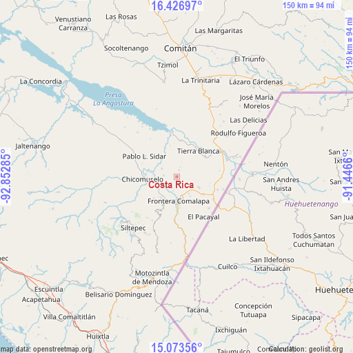
Costa Rica GPS coordinates[2]
15° 45' 5.004" North, 92° 8' 58.992" West
| Map corner | latitude | longitude |
|---|---|---|
| Upper-left | 16.42697°, | -92.85285° |
| Center: | 15.75139°, | -92.14972° |
| Lower-right: | 15.07356°, | -91.4466° |
| Map W x H: | 150.5×150.5 km | = 93.5×93.5mi |
| max Lat: | 32.7° ⇑98% North |
| Costa Rica: | 15.75139° |
| min Lat: | ⇓2% South 14.53588° |
| min Long | Costa Rica | max Long |
| -117.105° | -92.14972° | -86.73105° |
| W 94.5%⇐ | ⇒5.5% E |
Elevation
Elevation of Costa Rica is 663 m = 2175 ft, and this is 590.7 m = 1938 ft below average elevation for this country.
| Max E: |
3497 m = 11473 ft | 65.5% |
| Avg. | 1253.7 m = 4113 ft | |
| Costa Rica | 663 m = 2175 ft | |
Min E: |
-1 m = -3 ft | 34.5% |
See also: Mexico elevation on elevation.city.
Geographical zone
Costa Rica is located in North Torrid zone (between Equator and Tropic of Cancer). Distance of this Northern Tropic circle is 854.5 km =531 mi to North.| Distance of | km | miles | from Costa Rica |
|---|---|---|---|
| North Pole | 8255.7 | 5129.9 | to North |
| Arctic Circle | 5649.8 | 3510.6 | to North |
| Tropic Cancer | 854.5 | 531 | to North |
| Equator | 1751.4 | 1088.3 | to South |


Nearby cities:
15 places around Costa Rica: (largest is in red/bold)
• Bellavista del Norte
9.5 km =5.9 mi,  185°
185°
• Benito Juárez
10 km =6.2 mi,  323°
323°
• Comalapa
10.3 km =6.4 mi,  175°
175°
• El Anonal
7.4 km =4.6 mi,  162°
162°
• El Portal
10.1 km =6.3 mi,  145°
145°
• Guadalupe Grijalva
6 km =3.7 mi, 194°
• La Lima
9.9 km =6.2 mi,  167°
167°
• La Reforma
7.7 km =4.8 mi,  232°
232°
• La Sabinada
6.6 km =4.1 mi, 182°
• Nueva Independencia
7.2 km =4.5 mi,  298°
298°
• Nueva Libertad
5.5 km =3.4 mi,  275°
275°
• Nuevo Mazapa
2.9 km =1.8 mi,  20°
20°
• Nuevo México
8.8 km =5.5 mi,  144°
144°
• Santa Rosa
5.8 km =3.6 mi,  122°
122°
• Veinticuatro de Febrero
5.7 km =3.5 mi,  220°
220°
Sources, notices
• [Note1] Compared only with cities in Mexico existing in our database
• [Src1] Map data: © OpenStreetMap contributors (CC-BY-SA)
• [Src2] Other city data from geonames.org with taken over terms of usage.
• [Src3] Geographical zone / Annual Mean Temperature by Robert A. Rohde @ Wikipedia
