Los Ramones geodata
Los Ramones (Nuevo León) is a seat of a second-order administrative division; located in Mexico in America/Monterrey (GMT-6) time zone. With population of 1,169 people, there are 7428 cities with bigger population in this country. Compared to other cities in Mexico, 93.7% of cities are located further ↓South; 59% of cities are located further →East and 75.2% of cities have higher elevation than Los Ramones. Note1


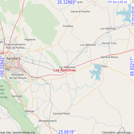
Los Ramones GPS coordinates[2]
25° 41' 49.776" North, 99° 37' 31.044" West
| Map corner | latitude | longitude |
|---|---|---|
| Upper-left | 26.32905°, | -100.32842° |
| Center: | 25.69716°, | -99.62529° |
| Lower-right: | 25.0619°, | -98.92217° |
| Map W x H: | 140.9×140.9 km | = 87.6×87.6mi |
| max Lat: | 32.7° ⇑6.3% North |
| Los Ramones: | 25.69716° |
| min Lat: | ⇓93.7% South 14.53588° |
| min Long | Los Ramones | max Long |
| -117.105° | -99.62529° | -86.73105° |
| W 41%⇐ | ⇒59% E |
Elevation
Elevation of Los Ramones is 214 m = 702 ft, and this is 1039.7 m = 3411 ft below average elevation for this country.
| Max E: |
3497 m = 11473 ft | 75.2% |
| Avg. | 1253.7 m = 4113 ft | |
| Los Ramones | 214 m = 702 ft | |
Min E: |
-1 m = -3 ft | 24.8% |
See also: Mexico elevation on elevation.city.
Geographical zone
Los Ramones is located in North temperate zone (between Tropic of Cancer and the Arctic Circle). Distance of this Northern Tropic circle is 251.3 km =156.2 mi to South.| Distance of | km | miles | from Los Ramones |
|---|---|---|---|
| North Pole | 7149.8 | 4442.7 | to North |
| Arctic Circle | 4543.9 | 2823.4 | to North |
| Tropic Cancer | 251.3 | 156.2 | to South |
| Equator | 2857.3 | 1775.4 | to South |


Nearby cities:
15 places around Los Ramones: (largest is in red/bold)
• Cadereyta
38.1 km =23.7 mi,  250°
250°
• Cadereyta Jiménez
39.6 km =24.6 mi, 252°
• China
39.2 km =24.4 mi,  89°
89°
• Ciudad Cerralvo
43.1 km =26.8 mi,  1°
1°
• Doctor González
36.7 km =22.8 mi,  299°
299°
• Los Herreras
32.2 km =20 mi,  43°
43°
• Marín
45.3 km =28.1 mi, 296°
• Melchor Ocampo
40.6 km =25.2 mi,  11°
11°
• Palmitos
43.3 km =26.9 mi,  233°
233°
• Pesquería
43.8 km =27.2 mi,  282°
282°
• Pueblo Nuevo
27.3 km =17 mi,  209°
209°
• San Antonio
43.9 km =27.3 mi,  261°
261°
• San Isidro
13.4 km =8.3 mi, 258°
• San Juan
27.6 km =17.1 mi, 231°
• Santa Isabel y Dolores
23.5 km =14.6 mi,  220°
220°
Sources, notices
• [Note1] Compared only with cities in Mexico existing in our database
• [Src1] Map data: © OpenStreetMap contributors (CC-BY-SA)
• [Src2] Other city data from geonames.org with taken over terms of usage.
• [Src3] Geographical zone / Annual Mean Temperature by Robert A. Rohde @ Wikipedia
