General Bravo geodata
General Bravo (Nuevo León) is a seat of a second-order administrative division; located in Mexico in America/Monterrey (GMT-6) time zone. With population of 3,927 people, there are 2327 cities with bigger population in this country. Compared to other cities in Mexico, 94.2% of cities are located further ↓South; 52.4% of cities are located further →East and 78.1% of cities have higher elevation than General Bravo. Note1


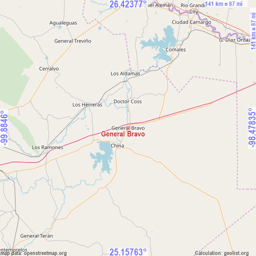
General Bravo GPS coordinates[2]
25° 47' 32.604" North, 99° 10' 53.292" West
| Map corner | latitude | longitude |
|---|---|---|
| Upper-left | 26.42377°, | -99.8846° |
| Center: | 25.79239°, | -99.18147° |
| Lower-right: | 25.15763°, | -98.47835° |
| Map W x H: | 140.8×140.8 km | = 87.5×87.5mi |
| max Lat: | 32.7° ⇑5.8% North |
| General Bravo: | 25.79239° |
| min Lat: | ⇓94.2% South 14.53588° |
| min Long | General Bravo | max Long |
| -117.105° | -99.18147° | -86.73105° |
| W 47.6%⇐ | ⇒52.4% E |
Elevation
Elevation of General Bravo is 130 m = 427 ft, and this is 1123.7 m = 3687 ft below average elevation for this country.
| Max E: |
3497 m = 11473 ft | 78.1% |
| Avg. | 1253.7 m = 4113 ft | |
| General Bravo | 130 m = 427 ft | |
Min E: |
-1 m = -3 ft | 21.9% |
See also: Mexico elevation on elevation.city.
Geographical zone
General Bravo is located in North temperate zone (between Tropic of Cancer and the Arctic Circle). Distance of this Northern Tropic circle is 261.9 km =162.7 mi to South.| Distance of | km | miles | from General Bravo |
|---|---|---|---|
| North Pole | 7139.2 | 4436.1 | to North |
| Arctic Circle | 4533.3 | 2816.9 | to North |
| Tropic Cancer | 261.9 | 162.7 | to South |
| Equator | 2867.8 | 1782 | to South |


Nearby cities:
15 places around General Bravo: (largest is in red/bold)
• Camargo
61.5 km =38.2 mi,  33°
33°
• China
11.6 km =7.2 mi,  207°
207°
• Ciudad Camargo
67.6 km =42 mi, 30°
• Ciudad Cerralvo
54.2 km =33.7 mi,  306°
306°
• Comales
50.6 km =31.4 mi, 31°
• Doctor Coss
14.7 km =9.1 mi,  359°
359°
• General Tapia (Mariano Escobedo)
14.7 km =9.1 mi,  75°
75°
• General Treviño
56.7 km =35.2 mi,  327°
327°
• Los Aldamas
30 km =18.6 mi, 357°
• Los Herreras
25.8 km =16 mi,  299°
299°
• Los Ramones
45.7 km =28.4 mi,  256°
256°
• Melchor Ocampo
46.5 km =28.9 mi, 308°
• Pueblo Nuevo
67.4 km =41.9 mi,  239°
239°
• San Isidro
59.1 km =36.7 mi, 257°
• Santa Isabel y Dolores
66.1 km =41.1 mi, 244°
Sources, notices
• [Note1] Compared only with cities in Mexico existing in our database
• [Src1] Map data: © OpenStreetMap contributors (CC-BY-SA)
• [Src2] Other city data from geonames.org with taken over terms of usage.
• [Src3] Geographical zone / Annual Mean Temperature by Robert A. Rohde @ Wikipedia
