El Tarral geodata
El Tarral (Chiapas) is a populated place; located in Mexico in America/Mexico_City (GMT-6) time zone. With population of 943 people, there are 9232 cities with bigger population in this country. Compared to other cities in Mexico, 99% of cities are located further ↑North; 92.8% of cities are located further ←West and 63.8% of cities have higher elevation than El Tarral. Note1


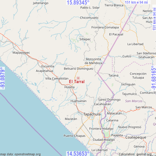
El Tarral GPS coordinates[2]
15° 12' 57.888" North, 92° 23' 5.172" West
| Map corner | latitude | longitude |
|---|---|---|
| Upper-left | 15.89345°, | -93.0879° |
| Center: | 15.21608°, | -92.38477° |
| Lower-right: | 14.53653°, | -91.68165° |
| Map W x H: | 150.9×150.9 km | = 93.8×93.8mi |
| max Lat: | 32.7° ⇑99% North |
| El Tarral: | 15.21608° |
| min Lat: | ⇓1% South 14.53588° |
| min Long | El Tarral | max Long |
| -117.105° | -92.38477° | -86.73105° |
| W 92.8%⇐ | ⇒7.2% E |
Elevation
Elevation of El Tarral is 761 m = 2497 ft, and this is 492.7 m = 1616 ft below average elevation for this country.
| Max E: |
3497 m = 11473 ft | 63.8% |
| Avg. | 1253.7 m = 4113 ft | |
| El Tarral | 761 m = 2497 ft | |
Min E: |
-1 m = -3 ft | 36.2% |
See also: Mexico elevation on elevation.city.
Geographical zone
El Tarral is located in North Torrid zone (between Equator and Tropic of Cancer). Distance of this Northern Tropic circle is 914 km =567.9 mi to North.| Distance of | km | miles | from El Tarral |
|---|---|---|---|
| North Pole | 8315.2 | 5166.8 | to North |
| Arctic Circle | 5709.3 | 3547.6 | to North |
| Tropic Cancer | 914 | 567.9 | to North |
| Equator | 1691.9 | 1051.3 | to South |


Nearby cities:
15 places around El Tarral: (largest is in red/bold)
• Belisario Domínguez
9.3 km =5.8 mi,  2°
2°
• Bremen
3.8 km =2.4 mi,  83°
83°
• Cantón Sinaí
6.8 km =4.2 mi,  108°
108°
• El Retiro
4.6 km =2.9 mi,  254°
254°
• Francisco Sarabia 1ra. Sección
6.6 km =4.1 mi,  197°
197°
• Guadalupe Victoria
6.3 km =3.9 mi, 201°
• La Flor
9.8 km =6.1 mi,  218°
218°
• Llano Grande
9.2 km =5.7 mi,  55°
55°
• Manacal
4.6 km =2.9 mi,  167°
167°
• Nueva América
9.8 km =6.1 mi,  320°
320°
• Nueva Independencia (Ampliación Calera)
4.2 km =2.6 mi,  103°
103°
• Nueva Tenochtitlán
4.1 km =2.5 mi,  232°
232°
• Tuzantán
8.7 km =5.4 mi,  207°
207°
• Veintinueve de Diciembre
10.8 km =6.7 mi, 221°
• Xochiltepec
11.1 km =6.9 mi, 208°
Sources, notices
• [Note1] Compared only with cities in Mexico existing in our database
• [Src1] Map data: © OpenStreetMap contributors (CC-BY-SA)
• [Src2] Other city data from geonames.org with taken over terms of usage.
• [Src3] Geographical zone / Annual Mean Temperature by Robert A. Rohde @ Wikipedia
