Nueva Tenochtitlán geodata
Nueva Tenochtitlán (Chiapas) is a populated place; located in Mexico in America/Mexico_City (GMT-6) time zone. With population of 900 people, there are 9690 cities with bigger population in this country. Compared to other cities in Mexico, 99% of cities are located further ↑North; 92.6% of cities are located further ←West and 74.3% of cities have higher elevation than Nueva Tenochtitlán. Note1


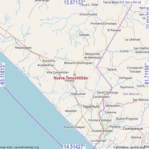
Nueva Tenochtitlán GPS coordinates[2]
15° 11' 38.004" North, 92° 24' 54" West
| Map corner | latitude | longitude |
|---|---|---|
| Upper-left | 15.87133°, | -93.11813° |
| Center: | 15.19389°, | -92.415° |
| Lower-right: | 14.51427°, | -91.71188° |
| Map W x H: | 150.9×150.9 km | = 93.8×93.8mi |
| max Lat: | 32.7° ⇑99% North |
| Nueva Tenochtitlán: | 15.19389° |
| min Lat: | ⇓1% South 14.53588° |
| min Long | Nueva Tenochtit | max Long |
| -117.105° | -92.415° | -86.73105° |
| W 92.6%⇐ | ⇒7.4% E |
Elevation
Elevation of Nueva Tenochtitlán is 243 m = 797 ft, and this is 1010.7 m = 3316 ft below average elevation for this country.
| Max E: |
3497 m = 11473 ft | 74.3% |
| Avg. | 1253.7 m = 4113 ft | |
| Nueva Tenochtitlán | 243 m = 797 ft | |
Min E: |
-1 m = -3 ft | 25.7% |
See also: Mexico elevation on elevation.city.
Geographical zone
Nueva Tenochtitlán is located in North Torrid zone (between Equator and Tropic of Cancer). Distance of this Northern Tropic circle is 916.5 km =569.5 mi to North.| Distance of | km | miles | from Nueva Tenochtitlán |
|---|---|---|---|
| North Pole | 8317.7 | 5168.4 | to North |
| Arctic Circle | 5711.8 | 3549.1 | to North |
| Tropic Cancer | 916.5 | 569.5 | to North |
| Equator | 1689.4 | 1049.7 | to South |


Nearby cities:
15 places around Nueva Tenochtitlán: (largest is in red/bold)
• Aquiles Serdán
7.7 km =4.8 mi,  238°
238°
• Bremen
7.6 km =4.7 mi,  67°
67°
• El Chipilín
8.3 km =5.2 mi,  188°
188°
• El Retiro
1.7 km =1.1 mi,  317°
317°
• El Tarral
4.1 km =2.5 mi,  52°
52°
• Francisco Sarabia 1ra. Sección
4 km =2.5 mi,  162°
162°
• Guadalupe Victoria
3.5 km =2.2 mi, 163°
• Huixtla
8.1 km =5 mi,  220°
220°
• La Flor
6 km =3.7 mi,  209°
209°
• Manacal
4.7 km =2.9 mi,  115°
115°
• Nueva Independencia (Ampliación Calera)
7.5 km =4.7 mi,  78°
78°
• Primer Cantón
8.6 km =5.3 mi,  198°
198°
• Tuzantán
5.3 km =3.3 mi, 188°
• Veintinueve de Diciembre
6.8 km =4.2 mi, 214°
• Xochiltepec
7.6 km =4.7 mi, 195°
Sources, notices
• [Note1] Compared only with cities in Mexico existing in our database
• [Src1] Map data: © OpenStreetMap contributors (CC-BY-SA)
• [Src2] Other city data from geonames.org with taken over terms of usage.
• [Src3] Geographical zone / Annual Mean Temperature by Robert A. Rohde @ Wikipedia
