Tuzantán geodata
Tuzantán (Chiapas) is a seat of a second-order administrative division; located in Mexico in America/Mexico_City (GMT-6) time zone. With population of 2,863 people, there are 3107 cities with bigger population in this country. Compared to other cities in Mexico, 99.1% of cities are located further ↑North; 92.6% of cities are located further ←West and 81.2% of cities have higher elevation than Tuzantán. Note1


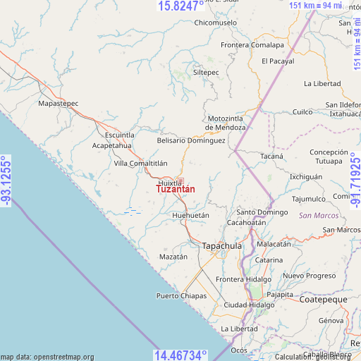
Tuzantán GPS coordinates[2]
15° 8' 49.596" North, 92° 25' 20.532" West
| Map corner | latitude | longitude |
|---|---|---|
| Upper-left | 15.8247°, | -93.1255° |
| Center: | 15.14711°, | -92.42237° |
| Lower-right: | 14.46734°, | -91.71925° |
| Map W x H: | 150.9×150.9 km | = 93.8×93.8mi |
| max Lat: | 32.7° ⇑99.1% North |
| Tuzantán: | 15.14711° |
| min Lat: | ⇓0.9% South 14.53588° |
| min Long | Tuzantán | max Long |
| -117.105° | -92.42237° | -86.73105° |
| W 92.6%⇐ | ⇒7.4% E |
Elevation
Elevation of Tuzantán is 79 m = 259 ft, and this is 1174.7 m = 3854 ft below average elevation for this country.
| Max E: |
3497 m = 11473 ft | 81.2% |
| Avg. | 1253.7 m = 4113 ft | |
| Tuzantán | 79 m = 259 ft | |
Min E: |
-1 m = -3 ft | 18.8% |
See also: Mexico elevation on elevation.city.
Geographical zone
Tuzantán is located in North Torrid zone (between Equator and Tropic of Cancer). Distance of this Northern Tropic circle is 921.7 km =572.7 mi to North.| Distance of | km | miles | from Tuzantán |
|---|---|---|---|
| North Pole | 8322.9 | 5171.6 | to North |
| Arctic Circle | 5717 | 3552.4 | to North |
| Tropic Cancer | 921.7 | 572.7 | to North |
| Equator | 1684.2 | 1046.5 | to South |


Nearby cities:
15 places around Tuzantán: (largest is in red/bold)
• Aquiles Serdán
5.9 km =3.7 mi,  282°
282°
• Cuarto Cantón
6.6 km =4.1 mi,  198°
198°
• El Chipilín
3 km =1.9 mi,  189°
189°
• El Retiro
6.5 km =4 mi,  356°
356°
• Estación Tuzantán
5.5 km =3.4 mi,  214°
214°
• Francisco Sarabia 1ra. Sección
2.4 km =1.5 mi,  55°
55°
• Guadalupe Victoria
2.5 km =1.6 mi,  44°
44°
• Huixtla
4.6 km =2.9 mi,  258°
258°
• La Flor
2.1 km =1.3 mi,  270°
270°
• Manacal
6 km =3.7 mi, 57°
• Nueva Tenochtitlán
5.3 km =3.3 mi,  8°
8°
• Primer Cantón
3.5 km =2.2 mi, 212°
• Segundo Cantón
5.4 km =3.4 mi, 194°
• Veintinueve de Diciembre
3.1 km =1.9 mi, 262°
• Xochiltepec
2.5 km =1.6 mi, 209°
Sources, notices
• [Note1] Compared only with cities in Mexico existing in our database
• [Src1] Map data: © OpenStreetMap contributors (CC-BY-SA)
• [Src2] Other city data from geonames.org with taken over terms of usage.
• [Src3] Geographical zone / Annual Mean Temperature by Robert A. Rohde @ Wikipedia
