Melchor Ocampo geodata
Melchor Ocampo (Hidalgo) is a populated place; located in Mexico in America/Mexico_City (GMT-6) time zone. With population of 4,679 people, there are 1970 cities with bigger population in this country. Compared to other cities in Mexico, 55.9% of cities are located further ↓South; 54% of cities are located further →East and 81.8% of cities have lower elevation than Melchor Ocampo. Note1


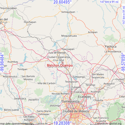
Melchor Ocampo GPS coordinates[2]
19° 56' 43.44" North, 99° 16' 54.156" West
| Map corner | latitude | longitude |
|---|---|---|
| Upper-left | 20.60495°, | -99.98484° |
| Center: | 19.9454°, | -99.28171° |
| Lower-right: | 19.28308°, | -98.57859° |
| Map W x H: | 147×147 km | = 91.3×91.3mi |
| max Lat: | 32.7° ⇑44.1% North |
| Melchor Ocampo: | 19.9454° |
| min Lat: | ⇓55.9% South 14.53588° |
| min Long | Melchor Ocampo | max Long |
| -117.105° | -99.28171° | -86.73105° |
| W 46%⇐ | ⇒54% E |
Elevation
Elevation of Melchor Ocampo is 2185 m = 7169 ft, and this is 931.3 m = 3055 ft above average elevation for this country.
| Max E: |
3497 m = 11473 ft | 18.2% |
| Melchor Ocampo | 2185 m 7169 ft | |
| Avg. | 1253.7 m = 4113 ft | |
Min E: |
-1 m = -3 ft | 81.8% |
See also: Mexico elevation on elevation.city.
Geographical zone
Melchor Ocampo is located in North Torrid zone (between Equator and Tropic of Cancer). Distance of this Northern Tropic circle is 388.2 km =241.2 mi to North.| Distance of | km | miles | from Melchor Ocampo |
|---|---|---|---|
| North Pole | 7789.3 | 4840 | to North |
| Arctic Circle | 5183.5 | 3220.9 | to North |
| Tropic Cancer | 388.2 | 241.2 | to North |
| Equator | 2217.7 | 1378 | to South |


Nearby cities:
15 places around Melchor Ocampo: (largest is in red/bold)
• Bomintzha
7.7 km =4.8 mi,  6°
6°
• Cañada
7.3 km =4.5 mi,  37°
37°
• Conejos
5.2 km =3.2 mi,  49°
49°
• El Pedregal
5 km =3.1 mi,  103°
103°
• Monte Alegre
7.5 km =4.7 mi,  303°
303°
• Paseos de la Pradera
7.6 km =4.7 mi,  142°
142°
• San Antonio
1.1 km =0.7 mi,  329°
329°
• San José Acoculco
3.3 km =2.1 mi,  322°
322°
• San Miguel Vindho
6.6 km =4.1 mi, 325°
• Santa María Ilucan
8 km =5 mi,  310°
310°
• Santiago Tlaltepoxco
7.2 km =4.5 mi,  162°
162°
• Tepeji del Río de Ocampo
7.9 km =4.9 mi,  235°
235°
• Tianguistengo (La Romera)
5.8 km =3.6 mi,  233°
233°
• Unidad Obrera Habitacional CTM
4.7 km =2.9 mi, 238°
• Zacamulpa
7.2 km =4.5 mi,  21°
21°
Sources, notices
• [Note1] Compared only with cities in Mexico existing in our database
• [Src1] Map data: © OpenStreetMap contributors (CC-BY-SA)
• [Src2] Other city data from geonames.org with taken over terms of usage.
• [Src3] Geographical zone / Annual Mean Temperature by Robert A. Rohde @ Wikipedia
