Venustiano Carranza Dos geodata
Venustiano Carranza Dos (Tamaulipas) is a populated place; located in Mexico in America/Monterrey (GMT-6) time zone. With population of 607 people, there are 14186 cities with bigger population in this country. Compared to other cities in Mexico, 87.7% of cities are located further ↓South; 54.6% of cities are located further ←West and 83.1% of cities have higher elevation than Venustiano Carranza Dos. Note1
Current local time in Venustiano Carranza Dos:
08:34 AM, WednesdayDifference from your time zone: hours


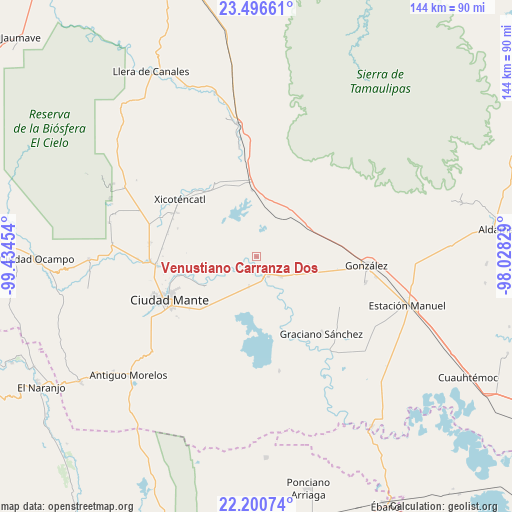
Venustiano Carranza Dos GPS coordinates[2]
22° 51' 0.792" North, 98° 43' 53.076" West
| Map corner | latitude | longitude |
|---|---|---|
| Upper-left | 23.49661°, | -99.43454° |
| Center: | 22.85022°, | -98.73141° |
| Lower-right: | 22.20074°, | -98.02829° |
| Map W x H: | 144.1×144.1 km | = 89.5×89.5mi |
| max Lat: | 32.7° ⇑12.3% North |
| Venustiano Carranza Dos: | 22.85022° |
| min Lat: | ⇓87.7% South 14.53588° |
| min Long | Venustiano Carr | max Long |
| -117.105° | -98.73141° | -86.73105° |
| W 54.6%⇐ | ⇒45.4% E |
Elevation
Elevation of Venustiano Carranza Dos is 59 m = 194 ft, and this is 1194.7 m = 3920 ft below average elevation for this country.
| Max E: |
3497 m = 11473 ft | 83.1% |
| Avg. | 1253.7 m = 4113 ft | |
| Venustiano Carranza Dos | 59 m = 194 ft | |
Min E: |
-1 m = -3 ft | 16.9% |
See also: Mexico elevation on elevation.city.
Geographical zone
Venustiano Carranza Dos is located in North Torrid zone (between Equator and Tropic of Cancer). Distance of this Northern Tropic circle is 65.2 km =40.5 mi to North.| Distance of | km | miles | from Venustiano Carranza Dos |
|---|---|---|---|
| North Pole | 7466.4 | 4639.4 | to North |
| Arctic Circle | 4860.5 | 3020.2 | to North |
| Tropic Cancer | 65.2 | 40.5 | to North |
| Equator | 2540.7 | 1578.7 | to South |


Nearby cities:
15 places around Venustiano Carranza Dos: (largest is in red/bold)
• Ciudad Mante
27.6 km =17.1 mi,  244°
244°
• El Camotero Dos
32.7 km =20.3 mi,  168°
168°
• El Limón
28.2 km =17.5 mi,  264°
264°
• Emiliano Zapata
23.9 km =14.9 mi,  232°
232°
• Emiliano Zapata
24.9 km =15.5 mi,  321°
321°
• González
31.3 km =19.4 mi,  94°
94°
• Graciano Sánchez
28.3 km =17.6 mi,  140°
140°
• Gómez Farías
30.4 km =18.9 mi,  277°
277°
• Magiscatzin
6.2 km =3.9 mi,  147°
147°
• Mártires de Río Blanco
28.2 km =17.5 mi,  265°
265°
• Plan de Ayala
34.7 km =21.6 mi,  186°
186°
• Primero de Mayo
25.5 km =15.8 mi,  298°
298°
• Santa Fe
31.5 km =19.6 mi,  103°
103°
• Segunda Unidad Xicoténcatl
23.5 km =14.6 mi, 321°
• Xicoténcatl
27 km =16.8 mi,  306°
306°
Sources, notices
• [Note1] Compared only with cities in Mexico existing in our database
• [Src1] Map data: © OpenStreetMap contributors (CC-BY-SA)
• [Src2] Other city data from geonames.org with taken over terms of usage.
• [Src3] Geographical zone / Annual Mean Temperature by Robert A. Rohde @ Wikipedia
