El Arenal geodata
El Arenal (Veracruz) is a populated place; located in Mexico in America/Mexico_City (GMT-6) time zone. With population of 716 people, there are 12166 cities with bigger population in this country. Compared to other cities in Mexico, 55.6% of cities are located further ↑North; 80.4% of cities are located further ←West and 92.1% of cities have higher elevation than El Arenal. Note1


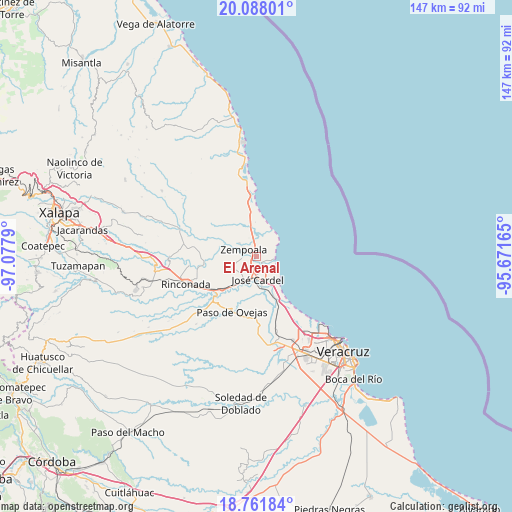
El Arenal GPS coordinates[2]
19° 25' 34.608" North, 96° 22' 29.172" West
| Map corner | latitude | longitude |
|---|---|---|
| Upper-left | 20.08801°, | -97.0779° |
| Center: | 19.42628°, | -96.37477° |
| Lower-right: | 18.76184°, | -95.67165° |
| Map W x H: | 147.5×147.5 km | = 91.7×91.7mi |
| max Lat: | 32.7° ⇑55.6% North |
| El Arenal: | 19.42628° |
| min Lat: | ⇓44.4% South 14.53588° |
| min Long | El Arenal | max Long |
| -117.105° | -96.37477° | -86.73105° |
| W 80.4%⇐ | ⇒19.6% E |
Elevation
Elevation of El Arenal is 19 m = 62 ft, and this is 1234.7 m = 4051 ft below average elevation for this country.
| Max E: |
3497 m = 11473 ft | 92.1% |
| Avg. | 1253.7 m = 4113 ft | |
| El Arenal | 19 m = 62 ft | |
Min E: |
-1 m = -3 ft | 7.9% |
See also: Mexico elevation on elevation.city.
Geographical zone
El Arenal is located in North Torrid zone (between Equator and Tropic of Cancer). Distance of this Northern Tropic circle is 445.9 km =277.1 mi to North.| Distance of | km | miles | from El Arenal |
|---|---|---|---|
| North Pole | 7847.1 | 4876 | to North |
| Arctic Circle | 5241.2 | 3256.7 | to North |
| Tropic Cancer | 445.9 | 277.1 | to North |
| Equator | 2160 | 1342.2 | to South |


Nearby cities:
15 places around El Arenal: (largest is in red/bold)
• Bara de Chachalacas
4.1 km =2.5 mi,  122°
122°
• Cabezas
6.1 km =3.8 mi,  187°
187°
• El Chalahuite
5.1 km =3.2 mi,  1°
1°
• El Paraíso (La Charca)
2.1 km =1.3 mi,  82°
82°
• Hornitos
6.2 km =3.9 mi,  308°
308°
• Infonavit el Pando I
3.1 km =1.9 mi,  196°
196°
• José Guadalupe Rodríguez (Despoblado)
4.2 km =2.6 mi,  263°
263°
• La Gloria
2.9 km =1.8 mi,  270°
270°
• Loma de San Rafael
3.5 km =2.2 mi, 117°
• Paso de Doña Juana
5.9 km =3.7 mi,  17°
17°
• Playa de Chachalacas
5.5 km =3.4 mi,  93°
93°
• Real del Oro
3.6 km =2.2 mi, 265°
• San Isidro
6.3 km =3.9 mi,  355°
355°
• Villa Zempoala
4 km =2.5 mi,  299°
299°
• Úrsulo Galván
2.7 km =1.7 mi,  148°
148°
Sources, notices
• [Note1] Compared only with cities in Mexico existing in our database
• [Src1] Map data: © OpenStreetMap contributors (CC-BY-SA)
• [Src2] Other city data from geonames.org with taken over terms of usage.
• [Src3] Geographical zone / Annual Mean Temperature by Robert A. Rohde @ Wikipedia
