Playa de Chachalacas geodata
Playa de Chachalacas (Veracruz) is a populated place; located in Mexico in America/Mexico_City (GMT-6) time zone. With population of 1,214 people, there are 7165 cities with bigger population in this country. Compared to other cities in Mexico, 55.7% of cities are located further ↑North; 80.8% of cities are located further ←West and 95.1% of cities have higher elevation than Playa de Chachalacas. Note1
Current local time in Playa de Chachalacas:
08:32 AM, WednesdayDifference from your time zone: hours


Playa de Chachalacas GPS coordinates[2]
19° 25' 24.672" North, 96° 19' 22.08" West
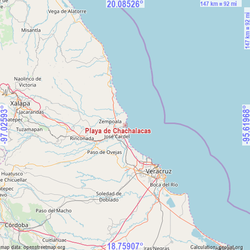
| Map corner | latitude | longitude |
|---|---|---|
| Upper-left | 20.08526°, | -97.02593° |
| Center: | 19.42352°, | -96.3228° |
| Lower-right: | 18.75907°, | -95.61968° |
| Map W x H: | 147.5×147.5 km | = 91.7×91.7mi |
| max Lat: | 32.7° ⇑55.7% North |
| Playa de Chachalacas: | 19.42352° |
| min Lat: | ⇓44.3% South 14.53588° |
| min Long | Playa de Chacha | max Long |
| -117.105° | -96.3228° | -86.73105° |
| W 80.8%⇐ | ⇒19.2% E |
Elevation
Elevation of Playa de Chachalacas is 13 m = 43 ft, and this is 1240.7 m = 4071 ft below average elevation for this country.
| Max E: |
3497 m = 11473 ft | 95.1% |
| Avg. | 1253.7 m = 4113 ft | |
| Playa de Chachalacas | 13 m = 43 ft | |
Min E: |
-1 m = -3 ft | 4.9% |
See also: Mexico elevation on elevation.city.
Geographical zone
Playa de Chachalacas is located in North Torrid zone (between Equator and Tropic of Cancer). Distance of this Northern Tropic circle is 446.2 km =277.3 mi to North.| Distance of | km | miles | from Playa de Chachalacas |
|---|---|---|---|
| North Pole | 7847.4 | 4876.1 | to North |
| Arctic Circle | 5241.5 | 3256.9 | to North |
| Tropic Cancer | 446.2 | 277.3 | to North |
| Equator | 2159.7 | 1342 | to South |


Nearby cities:
15 places around Playa de Chachalacas: (largest is in red/bold)
• Bara de Chachalacas
2.7 km =1.7 mi,  226°
226°
• Cabezas
8.5 km =5.3 mi, 227°
• El Arenal
5.5 km =3.4 mi,  273°
273°
• El Chalahuite
7.6 km =4.7 mi,  315°
315°
• El Paraíso (La Charca)
3.4 km =2.1 mi,  280°
280°
• Infonavit el Pando I
6.9 km =4.3 mi,  247°
247°
• José Cardel
7.9 km =4.9 mi,  218°
218°
• La Gloria
8.3 km =5.2 mi, 272°
• Loma de San Rafael
2.7 km =1.7 mi,  241°
241°
• Nicolás Blanco (San Pancho)
8.1 km =5 mi,  191°
191°
• Paso de Doña Juana
6.9 km =4.3 mi,  328°
328°
• Real del Oro
9.1 km =5.7 mi, 270°
• San Isidro
8.8 km =5.5 mi, 317°
• Villa Zempoala
9.2 km =5.7 mi, 284°
• Úrsulo Galván
4.5 km =2.8 mi, 243°
Sources, notices
• [Note1] Compared only with cities in Mexico existing in our database
• [Src1] Map data: © OpenStreetMap contributors (CC-BY-SA)
• [Src2] Other city data from geonames.org with taken over terms of usage.
• [Src3] Geographical zone / Annual Mean Temperature by Robert A. Rohde @ Wikipedia
