Úrsulo Galván geodata
Úrsulo Galván (Veracruz) is a seat of a second-order administrative division; located in Mexico in America/Mexico_City (GMT-6) time zone. With population of 5,259 people, there are 1760 cities with bigger population in this country. Compared to other cities in Mexico, 56.2% of cities are located further ↑North; 80.5% of cities are located further ←West and 97% of cities have higher elevation than Úrsulo Galván. Note1


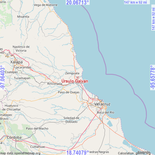
Úrsulo Galván GPS coordinates[2]
19° 24' 19.116" North, 96° 21' 39.24" West
| Map corner | latitude | longitude |
|---|---|---|
| Upper-left | 20.06713°, | -97.06403° |
| Center: | 19.40531°, | -96.3609° |
| Lower-right: | 18.74079°, | -95.65778° |
| Map W x H: | 147.5×147.5 km | = 91.7×91.7mi |
| max Lat: | 32.7° ⇑56.2% North |
| Úrsulo Galván: | 19.40531° |
| min Lat: | ⇓43.8% South 14.53588° |
| min Long | Úrsulo Galván | max Long |
| -117.105° | -96.3609° | -86.73105° |
| W 80.5%⇐ | ⇒19.5% E |
Elevation
Elevation of Úrsulo Galván is 10 m = 33 ft, and this is 1243.7 m = 4080 ft below average elevation for this country.
| Max E: |
3497 m = 11473 ft | 97% |
| Avg. | 1253.7 m = 4113 ft | |
| Úrsulo Galván | 10 m = 33 ft | |
Min E: |
-1 m = -3 ft | 3% |
See also: Mexico elevation on elevation.city.
Geographical zone
Úrsulo Galván is located in North Torrid zone (between Equator and Tropic of Cancer). Distance of this Northern Tropic circle is 448.3 km =278.6 mi to North.| Distance of | km | miles | from Úrsulo Galván |
|---|---|---|---|
| North Pole | 7849.4 | 4877.4 | to North |
| Arctic Circle | 5243.5 | 3258.2 | to North |
| Tropic Cancer | 448.3 | 278.6 | to North |
| Equator | 2157.7 | 1340.7 | to South |


Nearby cities:
15 places around Úrsulo Galván: (largest is in red/bold)
• Bara de Chachalacas
2 km =1.2 mi,  86°
86°
• Cabezas
4.4 km =2.7 mi,  211°
211°
• El Arenal
2.7 km =1.7 mi,  328°
328°
• El Paraíso (La Charca)
2.7 km =1.7 mi,  13°
13°
• Infonavit el Pando I
2.4 km =1.5 mi,  254°
254°
• José Cardel
4.2 km =2.6 mi,  192°
192°
• José Guadalupe Rodríguez (Despoblado)
5.9 km =3.7 mi,  288°
288°
• La Gloria
4.9 km =3 mi,  298°
298°
• Loma de San Rafael
1.8 km =1.1 mi,  66°
66°
• Nicolás Blanco (San Pancho)
6.3 km =3.9 mi,  158°
158°
• Playa de Chachalacas
4.5 km =2.8 mi,  63°
63°
• Real del Oro
5.5 km =3.4 mi, 292°
• Salmoral
7 km =4.3 mi,  175°
175°
• Villa Zempoala
6.5 km =4 mi,  311°
311°
• Yucatán
6.7 km =4.2 mi, 180°
Sources, notices
• [Note1] Compared only with cities in Mexico existing in our database
• [Src1] Map data: © OpenStreetMap contributors (CC-BY-SA)
• [Src2] Other city data from geonames.org with taken over terms of usage.
• [Src3] Geographical zone / Annual Mean Temperature by Robert A. Rohde @ Wikipedia
