Cabezas geodata
Cabezas (Veracruz) is a populated place; located in Mexico in America/Mexico_City (GMT-6) time zone. With population of 6,167 people, there are 1513 cities with bigger population in this country. Compared to other cities in Mexico, 57% of cities are located further ↑North; 80.4% of cities are located further ←West and 88.3% of cities have higher elevation than Cabezas. Note1


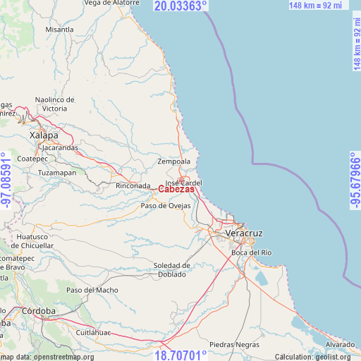
Cabezas GPS coordinates[2]
19° 22' 18.012" North, 96° 22' 58.008" West
| Map corner | latitude | longitude |
|---|---|---|
| Upper-left | 20.03363°, | -97.08591° |
| Center: | 19.37167°, | -96.38278° |
| Lower-right: | 18.70701°, | -95.67966° |
| Map W x H: | 147.5×147.5 km | = 91.7×91.7mi |
| max Lat: | 32.7° ⇑57% North |
| Cabezas: | 19.37167° |
| min Lat: | ⇓43% South 14.53588° |
| min Long | Cabezas | max Long |
| -117.105° | -96.38278° | -86.73105° |
| W 80.4%⇐ | ⇒19.6% E |
Elevation
Elevation of Cabezas is 29 m = 95 ft, and this is 1224.7 m = 4018 ft below average elevation for this country.
| Max E: |
3497 m = 11473 ft | 88.3% |
| Avg. | 1253.7 m = 4113 ft | |
| Cabezas | 29 m = 95 ft | |
Min E: |
-1 m = -3 ft | 11.7% |
See also: Mexico elevation on elevation.city.
Geographical zone
Cabezas is located in North Torrid zone (between Equator and Tropic of Cancer). Distance of this Northern Tropic circle is 452 km =280.9 mi to North.| Distance of | km | miles | from Cabezas |
|---|---|---|---|
| North Pole | 7853.1 | 4879.7 | to North |
| Arctic Circle | 5247.2 | 3260.5 | to North |
| Tropic Cancer | 452 | 280.9 | to North |
| Equator | 2153.9 | 1338.4 | to South |


Nearby cities:
15 places around Cabezas: (largest is in red/bold)
• Bara de Chachalacas
5.8 km =3.6 mi,  48°
48°
• El Arenal
6.1 km =3.8 mi,  7°
7°
• El Mango
5.4 km =3.4 mi,  184°
184°
• El Palmar
5.3 km =3.3 mi,  290°
290°
• Infonavit el Pando I
3.1 km =1.9 mi,  358°
358°
• José Cardel
1.4 km =0.9 mi,  105°
105°
• José Guadalupe Rodríguez (Despoblado)
6.5 km =4 mi,  329°
329°
• La Ceiba
6.3 km =3.9 mi, 180°
• La Gloria
6.4 km =4 mi,  341°
341°
• Loma de San Rafael
6 km =3.7 mi,  41°
41°
• Nicolás Blanco (San Pancho)
5.1 km =3.2 mi, 114°
• Real del Oro
6.4 km =4 mi, 334°
• Salmoral
4.3 km =2.7 mi,  139°
139°
• Yucatán
3.7 km =2.3 mi, 143°
• Úrsulo Galván
4.4 km =2.7 mi,  31°
31°
Sources, notices
• [Note1] Compared only with cities in Mexico existing in our database
• [Src1] Map data: © OpenStreetMap contributors (CC-BY-SA)
• [Src2] Other city data from geonames.org with taken over terms of usage.
• [Src3] Geographical zone / Annual Mean Temperature by Robert A. Rohde @ Wikipedia
