La Unión geodata
La Unión (Chiapas) is a populated place; located in Mexico in America/Mexico_City (GMT-6) time zone. With population of 921 people, there are 9483 cities with bigger population in this country. Compared to other cities in Mexico, 99.3% of cities are located further ↑North; 91.8% of cities are located further ←West and 93% of cities have higher elevation than La Unión. Note1


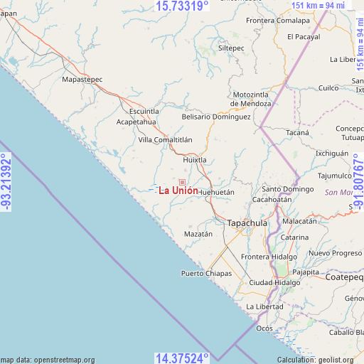
La Unión GPS coordinates[2]
15° 3' 19.08" North, 92° 30' 38.844" West
| Map corner | latitude | longitude |
|---|---|---|
| Upper-left | 15.73319°, | -93.21392° |
| Center: | 15.0553°, | -92.51079° |
| Lower-right: | 14.37524°, | -91.80767° |
| Map W x H: | 151×151 km | = 93.8×93.8mi |
| max Lat: | 32.7° ⇑99.3% North |
| La Unión: | 15.0553° |
| min Lat: | ⇓0.7% South 14.53588° |
| min Long | La Unión | max Long |
| -117.105° | -92.51079° | -86.73105° |
| W 91.8%⇐ | ⇒8.2% E |
Elevation
Elevation of La Unión is 17 m = 56 ft, and this is 1236.7 m = 4057 ft below average elevation for this country.
| Max E: |
3497 m = 11473 ft | 93% |
| Avg. | 1253.7 m = 4113 ft | |
| La Unión | 17 m = 56 ft | |
Min E: |
-1 m = -3 ft | 7% |
See also: Mexico elevation on elevation.city.
Geographical zone
La Unión is located in North Torrid zone (between Equator and Tropic of Cancer). Distance of this Northern Tropic circle is 931.9 km =579.1 mi to North.| Distance of | km | miles | from La Unión |
|---|---|---|---|
| North Pole | 8333.1 | 5177.9 | to North |
| Arctic Circle | 5727.2 | 3558.7 | to North |
| Tropic Cancer | 931.9 | 579.1 | to North |
| Equator | 1674 | 1040.2 | to South |


Nearby cities:
15 places around La Unión: (largest is in red/bold)
• Cantón Playa Grande
6.7 km =4.2 mi,  353°
353°
• Cantón Rancho Nuevo
2.1 km =1.3 mi,  310°
310°
• Cantón la Lima
8.9 km =5.5 mi,  111°
111°
• Cantón las Delicias
5.4 km =3.4 mi,  12°
12°
• Colonia Obrera
4.9 km =3 mi,  16°
16°
• Cuarto Cantón
8.4 km =5.2 mi,  61°
61°
• Cuyamiapa
10.1 km =6.3 mi,  101°
101°
• Efraín A. Gutiérrez
7.2 km =4.5 mi,  320°
320°
• El Arenal
4.1 km =2.5 mi,  40°
40°
• Estación Tuzantán
8.6 km =5.3 mi,  48°
48°
• Francisco I. Madero
4 km =2.5 mi,  294°
294°
• Nueva Victoria
5.6 km =3.5 mi,  134°
134°
• Plan de Ayala
8.8 km =5.5 mi,  155°
155°
• San José el Amate
10.3 km =6.4 mi, 130°
• Segundo Cantón
9.5 km =5.9 mi, 58°
Sources, notices
• [Note1] Compared only with cities in Mexico existing in our database
• [Src1] Map data: © OpenStreetMap contributors (CC-BY-SA)
• [Src2] Other city data from geonames.org with taken over terms of usage.
• [Src3] Geographical zone / Annual Mean Temperature by Robert A. Rohde @ Wikipedia
