Huixtla geodata
Huixtla (Chiapas) is a seat of a second-order administrative division; located in Mexico in America/Mexico_City (GMT-6) time zone. With population of 32,033 people, there are 316 cities with bigger population in this country. Compared to other cities in Mexico, 99.1% of cities are located further ↑North; 92.2% of cities are located further ←West and 83.9% of cities have higher elevation than Huixtla. Note1


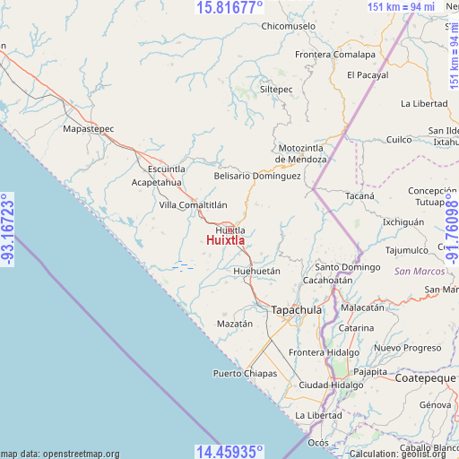
Huixtla GPS coordinates[2]
15° 8' 20.94" North, 92° 27' 50.76" West
| Map corner | latitude | longitude |
|---|---|---|
| Upper-left | 15.81677°, | -93.16723° |
| Center: | 15.13915°, | -92.4641° |
| Lower-right: | 14.45935°, | -91.76098° |
| Map W x H: | 150.9×150.9 km | = 93.8×93.8mi |
| max Lat: | 32.7° ⇑99.1% North |
| Huixtla: | 15.13915° |
| min Lat: | ⇓0.9% South 14.53588° |
| min Long | Huixtla | max Long |
| -117.105° | -92.4641° | -86.73105° |
| W 92.2%⇐ | ⇒7.8% E |
Elevation
Elevation of Huixtla is 52 m = 171 ft, and this is 1201.7 m = 3943 ft below average elevation for this country.
| Max E: |
3497 m = 11473 ft | 83.9% |
| Avg. | 1253.7 m = 4113 ft | |
| Huixtla | 52 m = 171 ft | |
Min E: |
-1 m = -3 ft | 16.1% |
See also: Mexico elevation on elevation.city.
Geographical zone
Huixtla is located in North Torrid zone (between Equator and Tropic of Cancer). Distance of this Northern Tropic circle is 922.6 km =573.3 mi to North.| Distance of | km | miles | from Huixtla |
|---|---|---|---|
| North Pole | 8323.7 | 5172.1 | to North |
| Arctic Circle | 5717.9 | 3552.9 | to North |
| Tropic Cancer | 922.6 | 573.3 | to North |
| Equator | 1683.3 | 1046 | to South |


Nearby cities:
15 places around Huixtla: (largest is in red/bold)
• Aquiles Serdán
2.5 km =1.6 mi,  328°
328°
• Cantón Playa Grande
6.4 km =4 mi,  245°
245°
• Cantón las Delicias
5.6 km =3.5 mi,  223°
223°
• Colonia Obrera
5.8 km =3.6 mi, 218°
• Cuarto Cantón
5.9 km =3.7 mi,  156°
156°
• El Arenal
6.6 km =4.1 mi,  200°
200°
• El Chipilín
4.5 km =2.8 mi,  117°
117°
• Estación Tuzantán
3.9 km =2.4 mi, 158°
• Guadalupe Victoria
6.8 km =4.2 mi,  66°
66°
• La Flor
2.5 km =1.6 mi, 69°
• Primer Cantón
3.3 km =2.1 mi,  128°
128°
• Segundo Cantón
5.3 km =3.3 mi,  144°
144°
• Tuzantán
4.6 km =2.9 mi,  78°
78°
• Veintinueve de Diciembre
1.5 km =0.9 mi, 70°
• Xochiltepec
3.5 km =2.2 mi,  111°
111°
Sources, notices
• [Note1] Compared only with cities in Mexico existing in our database
• [Src1] Map data: © OpenStreetMap contributors (CC-BY-SA)
• [Src2] Other city data from geonames.org with taken over terms of usage.
• [Src3] Geographical zone / Annual Mean Temperature by Robert A. Rohde @ Wikipedia
