Dzan geodata
Dzan (Yucatán) is a populated place; located in Mexico in America/Merida (GMT-6) time zone. With population of 4,939 people, there are 1870 cities with bigger population in this country. Compared to other cities in Mexico, 65.4% of cities are located further ↓South; 98.1% of cities are located further ←West and 87.7% of cities have higher elevation than Dzan. Note1


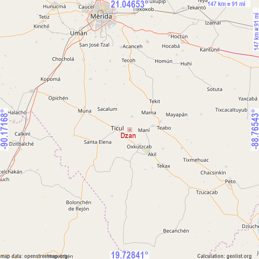
Dzan GPS coordinates[2]
20° 23' 19.968" North, 89° 28' 6.78" West
| Map corner | latitude | longitude |
|---|---|---|
| Upper-left | 21.04653°, | -90.17168° |
| Center: | 20.38888°, | -89.46855° |
| Lower-right: | 19.72841°, | -88.76543° |
| Map W x H: | 146.6×146.6 km | = 91.1×91.1mi |
| max Lat: | 32.7° ⇑34.6% North |
| Dzan: | 20.38888° |
| min Lat: | ⇓65.4% South 14.53588° |
| min Long | Dzan | max Long |
| -117.105° | -89.46855° | -86.73105° |
| W 98.1%⇐ | ⇒1.9% E |
Elevation
Elevation of Dzan is 31 m = 102 ft, and this is 1222.7 m = 4011 ft below average elevation for this country.
| Max E: |
3497 m = 11473 ft | 87.7% |
| Avg. | 1253.7 m = 4113 ft | |
| Dzan | 31 m = 102 ft | |
Min E: |
-1 m = -3 ft | 12.3% |
See also: Mexico elevation on elevation.city.
Geographical zone
Dzan is located in North Torrid zone (between Equator and Tropic of Cancer). Distance of this Northern Tropic circle is 338.9 km =210.6 mi to North.| Distance of | km | miles | from Dzan |
|---|---|---|---|
| North Pole | 7740 | 4809.4 | to North |
| Arctic Circle | 5134.1 | 3190.2 | to North |
| Tropic Cancer | 338.9 | 210.6 | to North |
| Equator | 2267 | 1408.6 | to South |


Nearby cities:
15 places around Dzan: (largest is in red/bold)
• Akil
18.6 km =11.6 mi,  137°
137°
• Chapab
7.9 km =4.9 mi,  8°
8°
• Chumayel
18 km =11.2 mi,  75°
75°
• Citincabchen
16 km =9.9 mi,  333°
333°
• Emiliano Zapata
18.1 km =11.2 mi,  179°
179°
• Mama
14.7 km =9.1 mi,  47°
47°
• Mani
8 km =5 mi,  90°
90°
• Oxkutzkab
10.5 km =6.5 mi,  149°
149°
• Pustunich
5 km =3.1 mi,  244°
244°
• Sacalum
17.5 km =10.9 mi,  313°
313°
• Santa Elena
19.4 km =12.1 mi,  249°
249°
• Teabo
19.4 km =12.1 mi, 86°
• Ticul
7 km =4.3 mi,  278°
278°
• Tipical
13.3 km =8.3 mi, 81°
• Yotholin
6.9 km =4.3 mi,  167°
167°
Sources, notices
• [Note1] Compared only with cities in Mexico existing in our database
• [Src1] Map data: © OpenStreetMap contributors (CC-BY-SA)
• [Src2] Other city data from geonames.org with taken over terms of usage.
• [Src3] Geographical zone / Annual Mean Temperature by Robert A. Rohde @ Wikipedia
