Sacalum geodata
Sacalum (Yucatán) is a populated place; located in Mexico in America/Merida (GMT-6) time zone. With population of 3,721 people, there are 2472 cities with bigger population in this country. Compared to other cities in Mexico, 67.7% of cities are located further ↓South; 98% of cities are located further ←West and 92.5% of cities have higher elevation than Sacalum. Note1


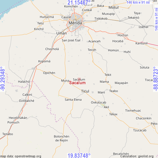
Sacalum GPS coordinates[2]
20° 29' 50.964" North, 89° 35' 25.26" West
| Map corner | latitude | longitude |
|---|---|---|
| Upper-left | 21.15467°, | -90.29348° |
| Center: | 20.49749°, | -89.59035° |
| Lower-right: | 19.83748°, | -88.88723° |
| Map W x H: | 146.5×146.5 km | = 91×91mi |
| max Lat: | 32.7° ⇑32.3% North |
| Sacalum: | 20.49749° |
| min Lat: | ⇓67.7% South 14.53588° |
| min Long | Sacalum | max Long |
| -117.105° | -89.59035° | -86.73105° |
| W 98%⇐ | ⇒2% E |
Elevation
Elevation of Sacalum is 18 m = 59 ft, and this is 1235.7 m = 4054 ft below average elevation for this country.
| Max E: |
3497 m = 11473 ft | 92.5% |
| Avg. | 1253.7 m = 4113 ft | |
| Sacalum | 18 m = 59 ft | |
Min E: |
-1 m = -3 ft | 7.5% |
See also: Mexico elevation on elevation.city.
Geographical zone
Sacalum is located in North Torrid zone (between Equator and Tropic of Cancer). Distance of this Northern Tropic circle is 326.8 km =203.1 mi to North.| Distance of | km | miles | from Sacalum |
|---|---|---|---|
| North Pole | 7728 | 4802 | to North |
| Arctic Circle | 5122.1 | 3182.7 | to North |
| Tropic Cancer | 326.8 | 203.1 | to North |
| Equator | 2279.1 | 1416.2 | to South |


Nearby cities:
15 places around Sacalum: (largest is in red/bold)
• Abala
19.2 km =11.9 mi,  330°
330°
• Chapab
14.5 km =9 mi,  107°
107°
• Citincabchen
6.1 km =3.8 mi,  67°
67°
• Dzan
17.5 km =10.9 mi,  133°
133°
• Mama
23.6 km =14.7 mi,  95°
95°
• Mani
24 km =14.9 mi,  120°
120°
• Muna
12.9 km =8 mi,  265°
265°
• Pustunich
16.4 km =10.2 mi,  150°
150°
• San José Tipceh
9.2 km =5.7 mi,  244°
244°
• Santa Elena
19.6 km =12.2 mi,  196°
196°
• Telchaquillo
21.2 km =13.2 mi,  38°
38°
• Temozon Sur
22.1 km =13.7 mi,  342°
342°
• Ticul
12.4 km =7.7 mi, 152°
• Uayalceh de Peón
21.8 km =13.5 mi,  358°
358°
• Yotholin
23.6 km =14.7 mi,  143°
143°
Sources, notices
• [Note1] Compared only with cities in Mexico existing in our database
• [Src1] Map data: © OpenStreetMap contributors (CC-BY-SA)
• [Src2] Other city data from geonames.org with taken over terms of usage.
• [Src3] Geographical zone / Annual Mean Temperature by Robert A. Rohde @ Wikipedia
