Chapab geodata
Chapab (Yucatán) is a populated place; located in Mexico in America/Merida (GMT-6) time zone. With population of 2,141 people, there are 4094 cities with bigger population in this country. Compared to other cities in Mexico, 66.9% of cities are located further ↓South; 98.2% of cities are located further ←West and 93.5% of cities have higher elevation than Chapab. Note1


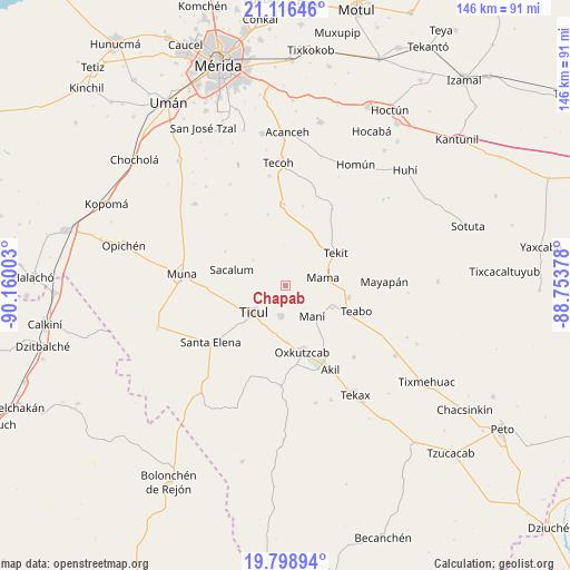
Chapab GPS coordinates[2]
20° 27' 32.796" North, 89° 27' 24.84" West
| Map corner | latitude | longitude |
|---|---|---|
| Upper-left | 21.11646°, | -90.16003° |
| Center: | 20.45911°, | -89.4569° |
| Lower-right: | 19.79894°, | -88.75378° |
| Map W x H: | 146.5×146.5 km | = 91×91mi |
| max Lat: | 32.7° ⇑33.1% North |
| Chapab: | 20.45911° |
| min Lat: | ⇓66.9% South 14.53588° |
| min Long | Chapab | max Long |
| -117.105° | -89.4569° | -86.73105° |
| W 98.2%⇐ | ⇒1.8% E |
Elevation
Elevation of Chapab is 16 m = 52 ft, and this is 1237.7 m = 4061 ft below average elevation for this country.
| Max E: |
3497 m = 11473 ft | 93.5% |
| Avg. | 1253.7 m = 4113 ft | |
| Chapab | 16 m = 52 ft | |
Min E: |
-1 m = -3 ft | 6.5% |
See also: Mexico elevation on elevation.city.
Geographical zone
Chapab is located in North Torrid zone (between Equator and Tropic of Cancer). Distance of this Northern Tropic circle is 331.1 km =205.7 mi to North.| Distance of | km | miles | from Chapab |
|---|---|---|---|
| North Pole | 7732.2 | 4804.6 | to North |
| Arctic Circle | 5126.3 | 3185.3 | to North |
| Tropic Cancer | 331.1 | 205.7 | to North |
| Equator | 2274.8 | 1413.5 | to South |


Nearby cities:
15 places around Chapab: (largest is in red/bold)
• Chumayel
16.6 km =10.3 mi,  101°
101°
• Citincabchen
10.6 km =6.6 mi,  308°
308°
• Dzan
7.9 km =4.9 mi,  188°
188°
• Mama
9.8 km =6.1 mi,  77°
77°
• Mani
10.4 km =6.5 mi,  139°
139°
• Oxkutzkab
17.4 km =10.8 mi,  166°
166°
• Pustunich
11.5 km =7.1 mi,  209°
209°
• Sacalum
14.5 km =9 mi,  287°
287°
• San José Tipceh
22.2 km =13.8 mi,  270°
270°
• Teabo
19.2 km =11.9 mi,  109°
109°
• Tekit
15.4 km =9.6 mi,  56°
56°
• Telchaquillo
20.9 km =13 mi,  358°
358°
• Ticul
10.6 km =6.6 mi,  230°
230°
• Tipical
13.3 km =8.3 mi,  115°
115°
• Yotholin
14.6 km =9.1 mi,  178°
178°
Sources, notices
• [Note1] Compared only with cities in Mexico existing in our database
• [Src1] Map data: © OpenStreetMap contributors (CC-BY-SA)
• [Src2] Other city data from geonames.org with taken over terms of usage.
• [Src3] Geographical zone / Annual Mean Temperature by Robert A. Rohde @ Wikipedia
