Pustunich geodata
Pustunich (Yucatán) is a populated place; located in Mexico in America/Merida (GMT-6) time zone. With population of 2,480 people, there are 3566 cities with bigger population in this country. Compared to other cities in Mexico, 64.9% of cities are located further ↓South; 98.1% of cities are located further ←West and 88.3% of cities have higher elevation than Pustunich. Note1


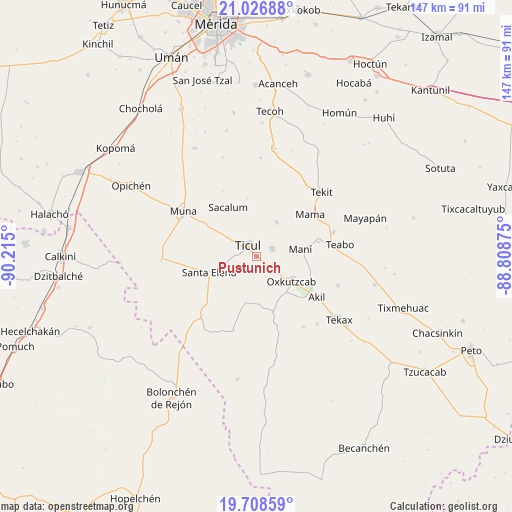
Pustunich GPS coordinates[2]
20° 22' 8.904" North, 89° 30' 42.732" West
| Map corner | latitude | longitude |
|---|---|---|
| Upper-left | 21.02688°, | -90.215° |
| Center: | 20.36914°, | -89.51187° |
| Lower-right: | 19.70859°, | -88.80875° |
| Map W x H: | 146.6×146.6 km | = 91.1×91.1mi |
| max Lat: | 32.7° ⇑35.1% North |
| Pustunich: | 20.36914° |
| min Lat: | ⇓64.9% South 14.53588° |
| min Long | Pustunich | max Long |
| -117.105° | -89.51187° | -86.73105° |
| W 98.1%⇐ | ⇒1.9% E |
Elevation
Elevation of Pustunich is 29 m = 95 ft, and this is 1224.7 m = 4018 ft below average elevation for this country.
| Max E: |
3497 m = 11473 ft | 88.3% |
| Avg. | 1253.7 m = 4113 ft | |
| Pustunich | 29 m = 95 ft | |
Min E: |
-1 m = -3 ft | 11.7% |
See also: Mexico elevation on elevation.city.
Geographical zone
Pustunich is located in North Torrid zone (between Equator and Tropic of Cancer). Distance of this Northern Tropic circle is 341.1 km =211.9 mi to North.| Distance of | km | miles | from Pustunich |
|---|---|---|---|
| North Pole | 7742.2 | 4810.8 | to North |
| Arctic Circle | 5136.3 | 3191.5 | to North |
| Tropic Cancer | 341.1 | 211.9 | to North |
| Equator | 2264.8 | 1407.3 | to South |


Nearby cities:
15 places around Pustunich: (largest is in red/bold)
• Akil
20.6 km =12.8 mi,  123°
123°
• Chapab
11.5 km =7.1 mi,  29°
29°
• Chumayel
22.9 km =14.2 mi,  73°
73°
• Citincabchen
16.8 km =10.4 mi,  351°
351°
• Dzan
5 km =3.1 mi,  64°
64°
• Emiliano Zapata
16.6 km =10.3 mi,  164°
164°
• Mama
19.6 km =12.2 mi,  51°
51°
• Mani
12.7 km =7.9 mi,  80°
80°
• Oxkutzkab
12 km =7.5 mi,  125°
125°
• Sacalum
16.4 km =10.2 mi,  330°
330°
• San José Tipceh
19.5 km =12.1 mi,  301°
301°
• Santa Elena
14.4 km =8.9 mi,  251°
251°
• Ticul
4.1 km =2.5 mi,  322°
322°
• Tipical
18.1 km =11.2 mi, 76°
• Yotholin
7.6 km =4.7 mi, 127°
Sources, notices
• [Note1] Compared only with cities in Mexico existing in our database
• [Src1] Map data: © OpenStreetMap contributors (CC-BY-SA)
• [Src2] Other city data from geonames.org with taken over terms of usage.
• [Src3] Geographical zone / Annual Mean Temperature by Robert A. Rohde @ Wikipedia
