Cuentepec geodata
Cuentepec (Morelos) is a populated place; located in Mexico in America/Mexico_City (GMT-6) time zone. With population of 3,371 people, there are 2694 cities with bigger population in this country. Compared to other cities in Mexico, 67.8% of cities are located further ↑North; 54.5% of cities are located further →East and 51.1% of cities have lower elevation than Cuentepec. Note1


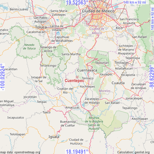
Cuentepec GPS coordinates[2]
18° 51' 41.724" North, 99° 19' 33.996" West
| Map corner | latitude | longitude |
|---|---|---|
| Upper-left | 19.52563°, | -100.02924° |
| Center: | 18.86159°, | -99.32611° |
| Lower-right: | 18.19491°, | -98.62299° |
| Map W x H: | 148×148 km | = 92×92mi |
| max Lat: | 32.7° ⇑67.8% North |
| Cuentepec: | 18.86159° |
| min Lat: | ⇓32.2% South 14.53588° |
| min Long | Cuentepec | max Long |
| -117.105° | -99.32611° | -86.73105° |
| W 45.5%⇐ | ⇒54.5% E |
Elevation
Elevation of Cuentepec is 1490 m = 4888 ft, and this is 236.3 m = 775 ft above average elevation for this country.
| Max E: |
3497 m = 11473 ft | 48.9% |
| Cuentepec | 1490 m 4888 ft | |
| Avg. | 1253.7 m = 4113 ft | |
Min E: |
-1 m = -3 ft | 51.1% |
See also: Mexico elevation on elevation.city.
Geographical zone
Cuentepec is located in North Torrid zone (between Equator and Tropic of Cancer). Distance of this Northern Tropic circle is 508.7 km =316.1 mi to North.| Distance of | km | miles | from Cuentepec |
|---|---|---|---|
| North Pole | 7909.8 | 4914.9 | to North |
| Arctic Circle | 5304 | 3295.8 | to North |
| Tropic Cancer | 508.7 | 316.1 | to North |
| Equator | 2097.2 | 1303.1 | to South |


Nearby cities:
15 places around Cuentepec: (largest is in red/bold)
• Ahuatenco
9.6 km =6 mi,  355°
355°
• Benito Juárez (La Monera)
8.1 km =5 mi,  131°
131°
• Buenavista del Monte
9.4 km =5.8 mi,  10°
10°
• Colonia Santa Úrsula
6.1 km =3.8 mi,  60°
60°
• El Mirador
10.2 km =6.3 mi,  189°
189°
• El Rodeo
9.2 km =5.7 mi,  177°
177°
• Eterna Primavera
7.4 km =4.6 mi,  105°
105°
• La Esperanza
11.6 km =7.2 mi,  120°
120°
• La Unión
8.9 km =5.5 mi, 64°
• Miacatlán
11.6 km =7.2 mi,  197°
197°
• Palpan de Baranda
10.9 km =6.8 mi,  274°
274°
• Solidaridad
6.4 km =4 mi,  98°
98°
• Temixco
10.6 km =6.6 mi, 95°
• Unidad Habitacional José María Morelos y Pavón
8.1 km =5 mi, 124°
• Xochicalco (Cirenio Longares)
8.7 km =5.4 mi,  161°
161°
Sources, notices
• [Note1] Compared only with cities in Mexico existing in our database
• [Src1] Map data: © OpenStreetMap contributors (CC-BY-SA)
• [Src2] Other city data from geonames.org with taken over terms of usage.
• [Src3] Geographical zone / Annual Mean Temperature by Robert A. Rohde @ Wikipedia
