Barrio de Nuevo León geodata
Barrio de Nuevo León (Puebla) is a populated place; located in Mexico in America/Mexico_City (GMT-6) time zone. With population of 2,067 people, there are 4219 cities with bigger population in this country. Compared to other cities in Mexico, 63.3% of cities are located further ↑North; 60% of cities are located further ←West and 81.4% of cities have lower elevation than Barrio de Nuevo León. Note1
Current local time in Barrio de Nuevo León:
06:48 AM, WednesdayDifference from your time zone: hours


Barrio de Nuevo León GPS coordinates[2]
19° 5' 18.996" North, 98° 17' 24" West
| Map corner | latitude | longitude |
|---|---|---|
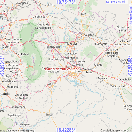
| Upper-left | 19.75173°, | -98.99313° |
| Center: | 19.08861°, | -98.29° |
| Lower-right: | 18.42283°, | -97.58688° |
| Map W x H: | 147.8×147.8 km | = 91.8×91.8mi |
| max Lat: | 32.7° ⇑63.3% North |
| Barrio de Nuevo León: | 19.08861° |
| min Lat: | ⇓36.7% South 14.53588° |
| min Long | Barrio de Nuevo | max Long |
| -117.105° | -98.29° | -86.73105° |
| W 60%⇐ | ⇒40% E |
Elevation
Elevation of Barrio de Nuevo León is 2173 m = 7129 ft, and this is 919.3 m = 3016 ft above average elevation for this country.
| Max E: |
3497 m = 11473 ft | 18.6% |
| Barrio de Nuevo León | 2173 m 7129 ft | |
| Avg. | 1253.7 m = 4113 ft | |
Min E: |
-1 m = -3 ft | 81.4% |
See also: Mexico elevation on elevation.city.
Geographical zone
Barrio de Nuevo León is located in North Torrid zone (between Equator and Tropic of Cancer). Distance of this Northern Tropic circle is 483.5 km =300.4 mi to North.| Distance of | km | miles | from Barrio de Nuevo León |
|---|---|---|---|
| North Pole | 7884.6 | 4899.3 | to North |
| Arctic Circle | 5278.7 | 3280 | to North |
| Tropic Cancer | 483.5 | 300.4 | to North |
| Equator | 2122.5 | 1318.9 | to South |


Nearby cities:
15 places around Barrio de Nuevo León: (largest is in red/bold)
• Cholula
3.1 km =1.9 mi,  207°
207°
• Coronango
4 km =2.5 mi,  334°
334°
• Cuanalá
4.6 km =2.9 mi,  299°
299°
• Cuautlancingo
1.8 km =1.1 mi,  85°
85°
• Fuerte de Guadalupe
0.9 km =0.6 mi,  188°
188°
• La Trinidad Chautenco
2.7 km =1.7 mi, 86°
• San Andrés Cholula
4.2 km =2.6 mi, 187°
• San Antonio Mihuacán
7.4 km =4.6 mi,  347°
347°
• San Bernardino Tlaxcalancingo
6.8 km =4.2 mi,  168°
168°
• San Diego los Sauces
1.1 km =0.7 mi, 205°
• San Francisco Ocotlán
5.1 km =3.2 mi,  7°
7°
• San Luis Tehuiloyocan
7.4 km =4.6 mi,  222°
222°
• Sanctorum
3.9 km =2.4 mi,  72°
72°
• Santiago Momoxpan
2.9 km =1.8 mi,  124°
124°
• Zacapechpan
7.5 km =4.7 mi,  239°
239°
Sources, notices
• [Note1] Compared only with cities in Mexico existing in our database
• [Src1] Map data: © OpenStreetMap contributors (CC-BY-SA)
• [Src2] Other city data from geonames.org with taken over terms of usage.
• [Src3] Geographical zone / Annual Mean Temperature by Robert A. Rohde @ Wikipedia
