Coyutla geodata
Coyutla (Veracruz) is a seat of a second-order administrative division; located in Mexico in America/Mexico_City (GMT-6) time zone. With population of 8,413 people, there are 1131 cities with bigger population in this country. Compared to other cities in Mexico, 62.4% of cities are located further ↓South; 67.8% of cities are located further ←West and 76.7% of cities have higher elevation than Coyutla. Note1


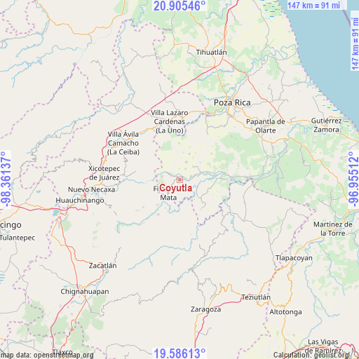
Coyutla GPS coordinates[2]
20° 14' 49.92" North, 97° 39' 29.664" West
| Map corner | latitude | longitude |
|---|---|---|
| Upper-left | 20.90546°, | -98.36137° |
| Center: | 20.2472°, | -97.65824° |
| Lower-right: | 19.58613°, | -96.95512° |
| Map W x H: | 146.7×146.7 km | = 91.2×91.2mi |
| max Lat: | 32.7° ⇑37.6% North |
| Coyutla: | 20.2472° |
| min Lat: | ⇓62.4% South 14.53588° |
| min Long | Coyutla | max Long |
| -117.105° | -97.65824° | -86.73105° |
| W 67.8%⇐ | ⇒32.2% E |
Elevation
Elevation of Coyutla is 161 m = 528 ft, and this is 1092.7 m = 3585 ft below average elevation for this country.
| Max E: |
3497 m = 11473 ft | 76.7% |
| Avg. | 1253.7 m = 4113 ft | |
| Coyutla | 161 m = 528 ft | |
Min E: |
-1 m = -3 ft | 23.3% |
See also: Mexico elevation on elevation.city.
Geographical zone
Coyutla is located in North Torrid zone (between Equator and Tropic of Cancer). Distance of this Northern Tropic circle is 354.6 km =220.3 mi to North.| Distance of | km | miles | from Coyutla |
|---|---|---|---|
| North Pole | 7755.8 | 4819.2 | to North |
| Arctic Circle | 5149.9 | 3200 | to North |
| Tropic Cancer | 354.6 | 220.3 | to North |
| Equator | 2251.3 | 1398.9 | to South |


Nearby cities:
15 places around Coyutla: (largest is in red/bold)
• Calalco
4.7 km =2.9 mi,  140°
140°
• Cerro Grande
2.7 km =1.7 mi,  248°
248°
• Cruz Verde
4.6 km =2.9 mi,  357°
357°
• El Arenal
7.2 km =4.5 mi,  71°
71°
• El Crucero
5.5 km =3.4 mi,  234°
234°
• El Panorama
5.2 km =3.2 mi,  26°
26°
• Filomeno Mata
7.1 km =4.4 mi,  222°
222°
• La Cruz
5.4 km =3.4 mi,  193°
193°
• Las Lomas
4.7 km =2.9 mi, 71°
• Lázaro Cárdenas (Santana)
7.2 km =4.5 mi,  109°
109°
• Macedonio Alonso
4.6 km =2.9 mi,  310°
310°
• Mecatlán
4.8 km =3 mi,  211°
211°
• Progreso de Zaragoza
6.4 km =4 mi,  298°
298°
• Rancho Alegre
4.9 km =3 mi,  155°
155°
• Ricardo Flores Magón
7.3 km =4.5 mi,  146°
146°
Sources, notices
• [Note1] Compared only with cities in Mexico existing in our database
• [Src1] Map data: © OpenStreetMap contributors (CC-BY-SA)
• [Src2] Other city data from geonames.org with taken over terms of usage.
• [Src3] Geographical zone / Annual Mean Temperature by Robert A. Rohde @ Wikipedia
