Las Lomas geodata
Las Lomas (Veracruz) is a populated place; located in Mexico in America/Mexico_City (GMT-6) time zone. With population of 1,811 people, there are 4807 cities with bigger population in this country. Compared to other cities in Mexico, 62.7% of cities are located further ↓South; 68.3% of cities are located further ←West and 77.3% of cities have higher elevation than Las Lomas. Note1


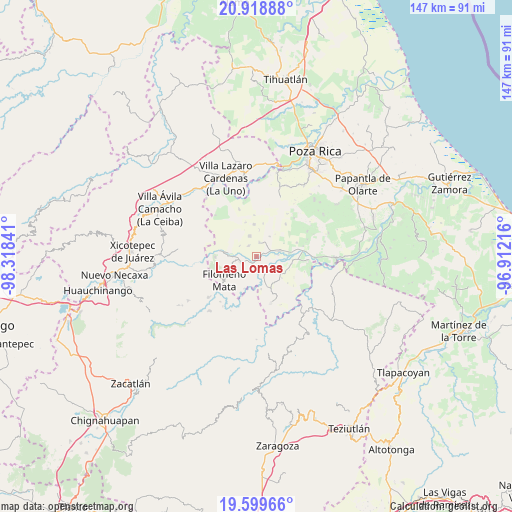
Las Lomas GPS coordinates[2]
20° 15' 38.412" North, 97° 36' 55.008" West
| Map corner | latitude | longitude |
|---|---|---|
| Upper-left | 20.91888°, | -98.31841° |
| Center: | 20.26067°, | -97.61528° |
| Lower-right: | 19.59966°, | -96.91216° |
| Map W x H: | 146.7×146.7 km | = 91.2×91.2mi |
| max Lat: | 32.7° ⇑37.3% North |
| Las Lomas: | 20.26067° |
| min Lat: | ⇓62.7% South 14.53588° |
| min Long | Las Lomas | max Long |
| -117.105° | -97.61528° | -86.73105° |
| W 68.3%⇐ | ⇒31.7% E |
Elevation
Elevation of Las Lomas is 145 m = 476 ft, and this is 1108.7 m = 3637 ft below average elevation for this country.
| Max E: |
3497 m = 11473 ft | 77.3% |
| Avg. | 1253.7 m = 4113 ft | |
| Las Lomas | 145 m = 476 ft | |
Min E: |
-1 m = -3 ft | 22.7% |
See also: Mexico elevation on elevation.city.
Geographical zone
Las Lomas is located in North Torrid zone (between Equator and Tropic of Cancer). Distance of this Northern Tropic circle is 353.1 km =219.4 mi to North.| Distance of | km | miles | from Las Lomas |
|---|---|---|---|
| North Pole | 7754.3 | 4818.3 | to North |
| Arctic Circle | 5148.4 | 3199.1 | to North |
| Tropic Cancer | 353.1 | 219.4 | to North |
| Equator | 2252.8 | 1399.8 | to South |


Nearby cities:
15 places around Las Lomas: (largest is in red/bold)
• Calalco
5.3 km =3.3 mi,  196°
196°
• Chumatlán
6.5 km =4 mi,  160°
160°
• Coyutla
4.7 km =2.9 mi,  251°
251°
• Cruz Verde
5.6 km =3.5 mi,  303°
303°
• El Arenal
2.5 km =1.6 mi,  70°
70°
• El Pacífico
4.9 km =3 mi, 72°
• El Panorama
3.8 km =2.4 mi,  326°
326°
• Entabladero
6.9 km =4.3 mi,  76°
76°
• La Noria
5.9 km =3.7 mi, 74°
• Lázaro Cárdenas (Santana)
4.6 km =2.9 mi,  149°
149°
• Manantiales
7 km =4.3 mi,  175°
175°
• Rancho Alegre
6.4 km =4 mi, 202°
• Sabanita
6.4 km =4 mi,  85°
85°
• San Leoncio Jamaya
6.8 km =4.2 mi,  31°
31°
• Tulapilla
6 km =3.7 mi,  342°
342°
Sources, notices
• [Note1] Compared only with cities in Mexico existing in our database
• [Src1] Map data: © OpenStreetMap contributors (CC-BY-SA)
• [Src2] Other city data from geonames.org with taken over terms of usage.
• [Src3] Geographical zone / Annual Mean Temperature by Robert A. Rohde @ Wikipedia
