Cosolapo geodata
Cosolapo (Veracruz) is a populated place; located in Mexico in America/Mexico_City (GMT-6) time zone. With population of 688 people, there are 12631 cities with bigger population in this country. Compared to other cities in Mexico, 61% of cities are located further ↑North; 75.9% of cities are located further ←West and 53.4% of cities have higher elevation than Cosolapo. Note1


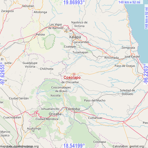
Cosolapo GPS coordinates[2]
19° 12' 26.28" North, 96° 55' 24.312" West
| Map corner | latitude | longitude |
|---|---|---|
| Upper-left | 19.86993°, | -97.62655° |
| Center: | 19.2073°, | -96.92342° |
| Lower-right: | 18.54199°, | -96.2203° |
| Map W x H: | 147.7×147.7 km | = 91.8×91.8mi |
| max Lat: | 32.7° ⇑61% North |
| Cosolapo: | 19.2073° |
| min Lat: | ⇓39% South 14.53588° |
| min Long | Cosolapo | max Long |
| -117.105° | -96.92342° | -86.73105° |
| W 75.9%⇐ | ⇒24.1% E |
Elevation
Elevation of Cosolapo is 1272 m = 4173 ft, and this is 18.3 m = 60 ft above average elevation for this country.
| Max E: |
3497 m = 11473 ft | 53.4% |
| Cosolapo | 1272 m 4173 ft | |
| Avg. | 1253.7 m = 4113 ft | |
Min E: |
-1 m = -3 ft | 46.6% |
See also: Mexico elevation on elevation.city.
Geographical zone
Cosolapo is located in North Torrid zone (between Equator and Tropic of Cancer). Distance of this Northern Tropic circle is 470.3 km =292.2 mi to North.| Distance of | km | miles | from Cosolapo |
|---|---|---|---|
| North Pole | 7871.4 | 4891.1 | to North |
| Arctic Circle | 5265.5 | 3271.8 | to North |
| Tropic Cancer | 470.3 | 292.2 | to North |
| Equator | 2135.7 | 1327.1 | to South |


Nearby cities:
15 places around Cosolapo: (largest is in red/bold)
• Chixtla
8.1 km =5 mi,  112°
112°
• Colonia San José
7.8 km =4.8 mi,  53°
53°
• Comapa
6.2 km =3.9 mi,  141°
141°
• Coyolito
6 km =3.7 mi,  67°
67°
• El Santuario (Barrio Nuevo)
7.9 km =4.9 mi,  20°
20°
• Huatusco
8 km =5 mi,  215°
215°
• Mata Obscura
7.4 km =4.6 mi,  80°
80°
• Ohuapan
8.2 km =5.1 mi,  305°
305°
• Sochiapa
2.4 km =1.5 mi,  227°
227°
• Tenampa
6.2 km =3.9 mi,  41°
41°
• Tlapala
6.1 km =3.8 mi,  4°
4°
• Tomatlancillo
3.4 km =2.1 mi,  194°
194°
• Totolapa (Cruz Verde)
4.3 km =2.7 mi,  261°
261°
• Totutla
4 km =2.5 mi,  277°
277°
• Zapotitla
3.7 km =2.3 mi,  322°
322°
Sources, notices
• [Note1] Compared only with cities in Mexico existing in our database
• [Src1] Map data: © OpenStreetMap contributors (CC-BY-SA)
• [Src2] Other city data from geonames.org with taken over terms of usage.
• [Src3] Geographical zone / Annual Mean Temperature by Robert A. Rohde @ Wikipedia
