Chixtla geodata
Chixtla (Veracruz) is a populated place; located in Mexico in America/Mexico_City (GMT-6) time zone. With population of 823 people, there are 10617 cities with bigger population in this country. Compared to other cities in Mexico, 61.6% of cities are located further ↑North; 76.6% of cities are located further ←West and 60.8% of cities have higher elevation than Chixtla. Note1


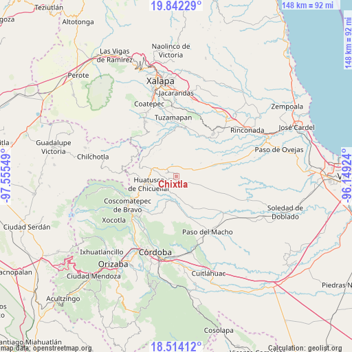
Chixtla GPS coordinates[2]
19° 10' 46.344" North, 96° 51' 8.496" West
| Map corner | latitude | longitude |
|---|---|---|
| Upper-left | 19.84229°, | -97.55549° |
| Center: | 19.17954°, | -96.85236° |
| Lower-right: | 18.51412°, | -96.14924° |
| Map W x H: | 147.7×147.7 km | = 91.8×91.8mi |
| max Lat: | 32.7° ⇑61.6% North |
| Chixtla: | 19.17954° |
| min Lat: | ⇓38.4% South 14.53588° |
| min Long | Chixtla | max Long |
| -117.105° | -96.85236° | -86.73105° |
| W 76.6%⇐ | ⇒23.4% E |
Elevation
Elevation of Chixtla is 954 m = 3130 ft, and this is 299.7 m = 983 ft below average elevation for this country.
| Max E: |
3497 m = 11473 ft | 60.8% |
| Avg. | 1253.7 m = 4113 ft | |
| Chixtla | 954 m = 3130 ft | |
Min E: |
-1 m = -3 ft | 39.2% |
See also: Mexico elevation on elevation.city.
Geographical zone
Chixtla is located in North Torrid zone (between Equator and Tropic of Cancer). Distance of this Northern Tropic circle is 473.4 km =294.2 mi to North.| Distance of | km | miles | from Chixtla |
|---|---|---|---|
| North Pole | 7874.5 | 4893 | to North |
| Arctic Circle | 5268.6 | 3273.8 | to North |
| Tropic Cancer | 473.4 | 294.2 | to North |
| Equator | 2132.6 | 1325.1 | to South |


Nearby cities:
15 places around Chixtla: (largest is in red/bold)
• Boca del Monte
3.5 km =2.2 mi,  143°
143°
• Capulapa
9.7 km =6 mi,  202°
202°
• Chavaxtla
5.9 km =3.7 mi,  157°
157°
• Colonia Manuel González
7.2 km =4.5 mi,  185°
185°
• Colonia San José
7.8 km =4.8 mi,  351°
351°
• Comapa
4 km =2.5 mi,  244°
244°
• Cosolapo
8.1 km =5 mi,  292°
292°
• Coyolito
5.7 km =3.5 mi,  340°
340°
• Mata Obscura
4.3 km =2.7 mi,  357°
357°
• Mata de Indio
5.8 km =3.6 mi,  11°
11°
• Puentecilla
9.3 km =5.8 mi,  178°
178°
• Sochiapa
9.3 km =5.8 mi,  279°
279°
• Tenampa
8.4 km =5.2 mi, 336°
• Tlacotepec de Mejía
1.9 km =1.2 mi,  53°
53°
• Tomatlancillo
8.3 km =5.2 mi,  268°
268°
Sources, notices
• [Note1] Compared only with cities in Mexico existing in our database
• [Src1] Map data: © OpenStreetMap contributors (CC-BY-SA)
• [Src2] Other city data from geonames.org with taken over terms of usage.
• [Src3] Geographical zone / Annual Mean Temperature by Robert A. Rohde @ Wikipedia
