Tomatlancillo geodata
Tomatlancillo (Veracruz) is a populated place; located in Mexico in America/Mexico_City (GMT-6) time zone. With population of 511 people, there are 16451 cities with bigger population in this country. Compared to other cities in Mexico, 61.6% of cities are located further ↑North; 75.8% of cities are located further ←West and 53.6% of cities have higher elevation than Tomatlancillo. Note1


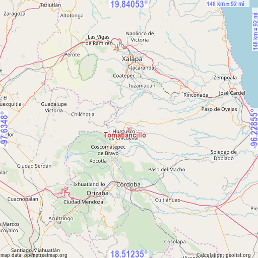
Tomatlancillo GPS coordinates[2]
19° 10' 40.008" North, 96° 55' 54.012" West
| Map corner | latitude | longitude |
|---|---|---|
| Upper-left | 19.84053°, | -97.6348° |
| Center: | 19.17778°, | -96.93167° |
| Lower-right: | 18.51235°, | -96.22855° |
| Map W x H: | 147.7×147.7 km | = 91.8×91.8mi |
| max Lat: | 32.7° ⇑61.6% North |
| Tomatlancillo: | 19.17778° |
| min Lat: | ⇓38.4% South 14.53588° |
| min Long | Tomatlancillo | max Long |
| -117.105° | -96.93167° | -86.73105° |
| W 75.8%⇐ | ⇒24.2% E |
Elevation
Elevation of Tomatlancillo is 1266 m = 4154 ft, and this is 12.3 m = 40 ft above average elevation for this country.
| Max E: |
3497 m = 11473 ft | 53.6% |
| Tomatlancillo | 1266 m 4154 ft | |
| Avg. | 1253.7 m = 4113 ft | |
Min E: |
-1 m = -3 ft | 46.4% |
See also: Mexico elevation on elevation.city.
Geographical zone
Tomatlancillo is located in North Torrid zone (between Equator and Tropic of Cancer). Distance of this Northern Tropic circle is 473.5 km =294.2 mi to North.| Distance of | km | miles | from Tomatlancillo |
|---|---|---|---|
| North Pole | 7874.7 | 4893.1 | to North |
| Arctic Circle | 5268.8 | 3273.9 | to North |
| Tropic Cancer | 473.5 | 294.2 | to North |
| Equator | 2132.4 | 1325 | to South |


Nearby cities:
15 places around Tomatlancillo: (largest is in red/bold)
• Adolfo Ruiz Cortines (La Pastoría)
8 km =5 mi,  243°
243°
• Amatiopa
7.3 km =4.5 mi,  189°
189°
• Chixtla
8.3 km =5.2 mi,  88°
88°
• Colonia Pastoría Cuatro
6.3 km =3.9 mi, 240°
• Comapa
5 km =3.1 mi,  107°
107°
• Cosolapo
3.4 km =2.1 mi,  14°
14°
• Coyolito
8.5 km =5.3 mi,  49°
49°
• Huatusco
5 km =3.1 mi,  229°
229°
• Ixpila
7.6 km =4.7 mi,  209°
209°
• Mesa del Rancho
5.9 km =3.7 mi,  198°
198°
• Michapa
8.4 km =5.2 mi, 196°
• Sochiapa
1.9 km =1.2 mi,  332°
332°
• Totolapa (Cruz Verde)
4.3 km =2.7 mi,  308°
308°
• Totutla
4.9 km =3 mi,  320°
320°
• Zapotitla
6.4 km =4 mi,  347°
347°
Sources, notices
• [Note1] Compared only with cities in Mexico existing in our database
• [Src1] Map data: © OpenStreetMap contributors (CC-BY-SA)
• [Src2] Other city data from geonames.org with taken over terms of usage.
• [Src3] Geographical zone / Annual Mean Temperature by Robert A. Rohde @ Wikipedia
