Copaltitla geodata
Copaltitla (Veracruz) is a populated place; located in Mexico in America/Mexico_City (GMT-6) time zone. With population of 586 people, there are 14641 cities with bigger population in this country. Compared to other cities in Mexico, 79% of cities are located further ↓South; 65.1% of cities are located further ←West and 72.2% of cities have higher elevation than Copaltitla. Note1


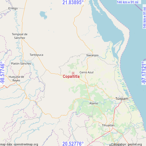
Copaltitla GPS coordinates[2]
21° 11' 5.316" North, 97° 52' 27.588" West
| Map corner | latitude | longitude |
|---|---|---|
| Upper-left | 21.83895°, | -98.57746° |
| Center: | 21.18481°, | -97.87433° |
| Lower-right: | 20.52776°, | -97.17121° |
| Map W x H: | 145.8×145.8 km | = 90.6×90.6mi |
| max Lat: | 32.7° ⇑21% North |
| Copaltitla: | 21.18481° |
| min Lat: | ⇓79% South 14.53588° |
| min Long | Copaltitla | max Long |
| -117.105° | -97.87433° | -86.73105° |
| W 65.1%⇐ | ⇒34.9% E |
Elevation
Elevation of Copaltitla is 322 m = 1056 ft, and this is 931.7 m = 3057 ft below average elevation for this country.
| Max E: |
3497 m = 11473 ft | 72.2% |
| Avg. | 1253.7 m = 4113 ft | |
| Copaltitla | 322 m = 1056 ft | |
Min E: |
-1 m = -3 ft | 27.8% |
See also: Mexico elevation on elevation.city.
Geographical zone
Copaltitla is located in North Torrid zone (between Equator and Tropic of Cancer). Distance of this Northern Tropic circle is 250.4 km =155.6 mi to North.| Distance of | km | miles | from Copaltitla |
|---|---|---|---|
| North Pole | 7651.5 | 4754.4 | to North |
| Arctic Circle | 5045.6 | 3135.2 | to North |
| Tropic Cancer | 250.4 | 155.6 | to North |
| Equator | 2355.5 | 1463.6 | to South |


Nearby cities:
15 places around Copaltitla: (largest is in red/bold)
• Cerro Azul
13.9 km =8.6 mi,  86°
86°
• Chontla
13.4 km =8.3 mi,  337°
337°
• El Gavilán
14.2 km =8.8 mi,  281°
281°
• El Humo
7.1 km =4.4 mi,  261°
261°
• Francia Nueva
11.1 km =6.9 mi,  227°
227°
• Juan Felipe
11.5 km =7.1 mi,  106°
106°
• La Guásima
8.8 km =5.5 mi,  154°
154°
• Las Cruces
11.4 km =7.1 mi,  316°
316°
• Piedra Labrada
8.4 km =5.2 mi,  82°
82°
• Tancoco
14.2 km =8.8 mi,  37°
37°
• Tecomate
4.2 km =2.6 mi,  159°
159°
• Tepetzintla
3.2 km =2 mi,  135°
135°
• Tierra Blanca
5.5 km =3.4 mi,  239°
239°
• Tlacolula
13.6 km =8.5 mi,  220°
220°
• Zapotitlán
10.1 km =6.3 mi, 142°
Sources, notices
• [Note1] Compared only with cities in Mexico existing in our database
• [Src1] Map data: © OpenStreetMap contributors (CC-BY-SA)
• [Src2] Other city data from geonames.org with taken over terms of usage.
• [Src3] Geographical zone / Annual Mean Temperature by Robert A. Rohde @ Wikipedia
