Chontla geodata
Chontla (Veracruz) is a seat of a second-order administrative division; located in Mexico in America/Mexico_City (GMT-6) time zone. With population of 2,320 people, there are 3806 cities with bigger population in this country. Compared to other cities in Mexico, 80% of cities are located further ↓South; 64.5% of cities are located further ←West and 73.8% of cities have higher elevation than Chontla. Note1


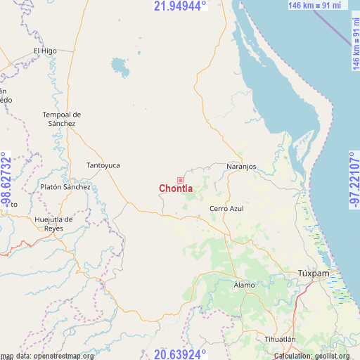
Chontla GPS coordinates[2]
21° 17' 44.88" North, 97° 55' 27.084" West
| Map corner | latitude | longitude |
|---|---|---|
| Upper-left | 21.94944°, | -98.62732° |
| Center: | 21.2958°, | -97.92419° |
| Lower-right: | 20.63924°, | -97.22107° |
| Map W x H: | 145.7×145.7 km | = 90.5×90.5mi |
| max Lat: | 32.7° ⇑20% North |
| Chontla: | 21.2958° |
| min Lat: | ⇓80% South 14.53588° |
| min Long | Chontla | max Long |
| -117.105° | -97.92419° | -86.73105° |
| W 64.5%⇐ | ⇒35.5% E |
Elevation
Elevation of Chontla is 262 m = 860 ft, and this is 991.7 m = 3254 ft below average elevation for this country.
| Max E: |
3497 m = 11473 ft | 73.8% |
| Avg. | 1253.7 m = 4113 ft | |
| Chontla | 262 m = 860 ft | |
Min E: |
-1 m = -3 ft | 26.2% |
See also: Mexico elevation on elevation.city.
Geographical zone
Chontla is located in North Torrid zone (between Equator and Tropic of Cancer). Distance of this Northern Tropic circle is 238 km =147.9 mi to North.| Distance of | km | miles | from Chontla |
|---|---|---|---|
| North Pole | 7639.2 | 4746.8 | to North |
| Arctic Circle | 5033.3 | 3127.5 | to North |
| Tropic Cancer | 238 | 147.9 | to North |
| Equator | 2367.9 | 1471.3 | to South |


Nearby cities:
15 places around Chontla: (largest is in red/bold)
• Citlaltépec
6 km =3.7 mi,  51°
51°
• Copaltitla
13.4 km =8.3 mi,  157°
157°
• Cruz Manantial
6.1 km =3.8 mi,  301°
301°
• El Gavilán
12.9 km =8 mi,  222°
222°
• El Humo
13.5 km =8.4 mi,  187°
187°
• El Naranjal
5.5 km =3.4 mi,  39°
39°
• Ixcatepec
10.8 km =6.7 mi,  232°
232°
• La Garita
2.2 km =1.4 mi,  13°
13°
• Las Cruces
4.9 km =3 mi,  212°
212°
• Las Sabinas
5.1 km =3.2 mi,  61°
61°
• Mata de Otate
8.6 km =5.3 mi,  312°
312°
• Rancho Nuevo
7.7 km =4.8 mi,  18°
18°
• San Francisco
3.1 km =1.9 mi,  255°
255°
• Tamalín
12.6 km =7.8 mi,  67°
67°
• Tantima
10.3 km =6.4 mi, 66°
Sources, notices
• [Note1] Compared only with cities in Mexico existing in our database
• [Src1] Map data: © OpenStreetMap contributors (CC-BY-SA)
• [Src2] Other city data from geonames.org with taken over terms of usage.
• [Src3] Geographical zone / Annual Mean Temperature by Robert A. Rohde @ Wikipedia
